Category:1650s maps of Africa
Jump to navigation
Jump to search
Temperate regions: North America · South America · Africa · Europe · Asia · Oceania – Polar regions: – Other regions:
Subcategories
This category has the following 12 subcategories, out of 12 total.
- 1650 maps of Africa (7 F)
- 1653 maps of Africa (3 F)
- 1654 maps of Africa (3 F)
- 1655 maps of Africa (7 F)
- 1656 maps of Africa (5 F)
- 1657 maps of Africa (2 F)
- 1658 maps of Africa (5 F)
- 1659 maps of Africa (7 F)
E
- 1650s maps of Egypt (8 F)
- 1650s maps of Ethiopia (3 F)
L
- 1650s maps of Libya (7 F)
T
- 1650s maps of Tunisia (6 F)
Media in category "1650s maps of Africa"
The following 8 files are in this category, out of 8 total.
-
 Africa North 1650, Jan Janssonius (4159266-recto).jpg 7,091 × 6,006; 8.11 MB
-
 A-3-37-13-Africa.jpg 3,000 × 2,261; 1.17 MB
-
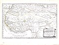 A-3-37-18-North-Africa-Guinea.jpg 3,000 × 2,281; 807 KB
-
 A-3-37-19-Ethiopia.jpg 3,000 × 2,267; 1.03 MB
-
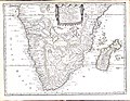 A-3-37-20-Southern-Africa.jpg 3,000 × 2,323; 1.03 MB
-
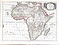 A-3-37-38-Africa.jpg 3,000 × 2,272; 1.03 MB
-

-
 Polus Antarcticus. R 2= 22. Pièce 90.jpg 9,056 × 7,088; 11.5 MB
.jpg)


