Category:1663 maps of Canada
Jump to navigation
Jump to search
Countries of North America: Canada
| 1660 1662 1663 1664 1666 |
English: Maps of Canada from 1663 or related to Canada in 1663
Français : Les cartes du Canada de 1663 ou se rapportant au Canada en 1663
Subcategories
This category has only the following subcategory.
Media in category "1663 maps of Canada"
The following 3 files are in this category, out of 3 total.
-
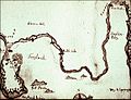 James Yonge's map of Ferryland, ca. 1663..jpg 580 × 446; 65 KB
-
 Le Veritable plan de Quebec fait en 1663 - Vieux-Quebec.jpg 1,822 × 1,479; 1.03 MB
-
 Le Veritable plan de Quebec fait en 1663.jpg 6,289 × 2,501; 3.49 MB

