Category:167 - 171 Duke Street, Liverpool
Jump to navigation
Jump to search
| Object location | | View all coordinates using: OpenStreetMap |
|---|
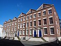
building in Liverpool, Merseyside, England, UK  | |||||
| Upload media | |||||
| Instance of | |||||
|---|---|---|---|---|---|
| Location | Liverpool, Merseyside, North West England, England | ||||
| Heritage designation |
| ||||
 | |||||
It's not clear here how the numbers relate to the EH listing because the doors are not numbered.
Media in category "167 - 171 Duke Street, Liverpool"
The following 5 files are in this category, out of 5 total.
-
 167 - 171 Duke Street, Liverpool 1.jpg 4,730 × 3,245; 8.58 MB
-
 167 - 171 Duke Street, Liverpool 2.jpg 4,690 × 3,096; 7.99 MB
-
 Houses on Duke Street, Liverpool (1).jpg 5,152 × 3,864; 7.71 MB
-
 Houses on Duke Street, Liverpool (2).jpg 5,152 × 3,864; 7.57 MB
-
 Rear of 167 - 171 Duke Street.jpg 5,071 × 3,296; 8.19 MB

.jpg)
.jpg)
