Category:1730s maps of the Caribbean
Jump to navigation
Jump to search
Subcategories
This category has the following 5 subcategories, out of 5 total.
B
- 1730s maps of the Bahamas (2 F)
- 1730s maps of Bermuda (1 F)
C
- 1730s maps of Cuba (12 F)
Media in category "1730s maps of the Caribbean"
The following 40 files are in this category, out of 40 total.
-

-
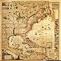
 (Map showing Gulf of Mexico including western portion of Caribbean area). LOC 91683704.jpg 7,043 × 9,749; 8.21 MB
-
 (Map showing Gulf of Mexico including western portion of Caribbean area). LOC 91683704.tif 7,043 × 9,749; 196.44 MB
-
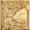
 (Map showing Gulf of Mexico including western portion of Caribbean area). LOC 91683705.jpg 10,824 × 13,031; 21.35 MB
-
 (Map showing Gulf of Mexico including western portion of Caribbean area). LOC 91683705.tif 10,824 × 13,031; 403.54 MB
-

-
-

-

-
 A chart of the Caribe Islands (9495452356).jpg 800 × 644; 142 KB
-

-

-

-

-

-

-

-
-
-

-

-

-

-

-

-

-

-

-

-

-
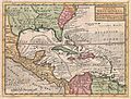
 A map of the British Empire in America.jpg 4,235 × 4,433; 8.53 MB
-

-

-

-
 Carte des Antilles françoises et des isles voisines (4579408086).jpg 7,921 × 9,286; 19.74 MB
-

-
 Mapa geographica completens Indiae Occidentalis.jpg 3,102 × 3,677; 3.18 MB
-
 Moll - A Map of the West-Indies.png 1,200 × 907; 2.32 MB
-
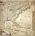
 Carte contenant le royaume du Mexique et la Floride (NYPL b20292772-5476418).jpg 7,882 × 6,249; 45.44 MB
-
 TierraFirme.jpg 800 × 596; 344 KB
_A_map_of_the_British_Empire_in_America_with_the_French_and_Spanish_settlements_adjacent_thereto_-_DPLA_-_5c46256a977d375603cac71e4fa18718_(page_1).jpg)
._LOC_91683704.jpg)
._LOC_91683705.jpg)


.jpg)

.jpg)


.jpg)
.jpg)
.jpg)
.jpg)
.jpg)
.jpg)
_-_by_Henry_Popple_;_engrav%27d_by_Will._Henry_Toms_-_btv1b53053052r.jpg)

.jpg)
.jpg)
.jpg)
,_BI-B-FM-090-63.jpg)


.jpg)
