Category:1732 maps of New Jersey
Jump to navigation
Jump to search
States of the United States: Connecticut · Maryland · Massachusetts · New Jersey · New York · Pennsylvania · Rhode Island
| ← 1732 1737 |
Media in category "1732 maps of New Jersey"
The following 6 files are in this category, out of 6 total.
-
 New England, New York, New Jersey and Pensilvania - by H. Moll, geographer. NYPL434019.tiff 4,632 × 3,904; 51.77 MB
-
 New England, New York, New Jersey and Pensilvania NYPL483697.tiff 3,959 × 3,456; 39.18 MB
-
 New England, New York, New Jersey and Pensilvania NYPL483698.tiff 4,408 × 3,728; 47.05 MB
-
 New England, New York, New Jersey and Pensilvania (NYPL b15073991-434019).jpg 4,632 × 3,904; 3.77 MB
-
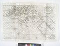
 New England, New York, New Jersey and Pensilvania (NYPL b15073991-483698).jpg 4,408 × 3,728; 3.48 MB
-
 Virginia, Maryland, Pennsilvania, east and west New Jarsey NYPL481130.tiff 5,915 × 4,584; 77.58 MB
.jpg)
.jpg)