Category:1772 map of Ukraine by Giovanni Antonio Rizzi Zannoni
Jump to navigation
Jump to search
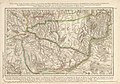
English: Trilingual map of today's Ukraine in 1767; titled in Polish, French and (Tatarian? Ottoman Turkish?); labeled with script in Latin and Turk-Arab(?) letters, the main entities shown are "Osady Zaporoюwcow" and "Ouzi-Kala Tatarlerinugn Topraghi".
Title: Map of the borders of Poland from Balta to the river of Sina-Woda (?), including the territories of the Cossacks of Uman and Zaporov (Zaporizhzhia?); the deserts of the Tatars of Oczakow, of Bessarabia and Nogai with their hordes placed as of the end of 1767 by the orders of the Crimean Khan. Bog and Dniester with the course of the Boristhène from the Cataracts down to its mouth at the Black Sea.
Title: Map of the borders of Poland from Balta to the river of Sina-Woda (?), including the territories of the Cossacks of Uman and Zaporov (Zaporizhzhia?); the deserts of the Tatars of Oczakow, of Bessarabia and Nogai with their hordes placed as of the end of 1767 by the orders of the Crimean Khan. Bog and Dniester with the course of the Boristhène from the Cataracts down to its mouth at the Black Sea.
Polski: Karta granic Polski, Zacząwszy od Balty, aż do Rzeki Sina-Woda, Zawieraiąca Slobody Kozakow, Humańskich, y Zaporohowskich; Stépy Tatarow, Oczakowskich, Bessarabskich, y Nogayskich, z Ich Ordami, tak ie w Roku M.DCC.LXVII. Han-Krymski Poosadzal. Znayduie się tu Ieszcze, Dalsze Wyciągnienie Bógu, y Dniestru; Dnieper Także od Pohorow, aż do Wpadnienia w Morze Czarne.
Français : Carte des Frontiéres de Pologne depuis Balta jusques à la riviere de Sina-Woda; content le Territoire des Kosaks de Human et de Zaporow; les deserts des Tatares d'Oczakow, de Bessarabie et du Nogaï avec leurs Hordes telles qu'elles furent situées à la fin de 1767, par les ordres du Khan de Krimée. Bog et du Dniester, avec le cours du Boristhène depuis les Cataractes jusques à son embouchûre dans la Mer Noire.
Media in category "1772 map of Ukraine by Giovanni Antonio Rizzi Zannoni"
The following 7 files are in this category, out of 7 total.
-

-
 Carte des frontières de Pologne... - btv1b53192167z (15 of 16).jpg 8,234 × 6,136; 9.02 MB
-
 Fragment Carte de Pologne von Rizzi-Zannoni 1667.jpg 1,089 × 933; 280 KB
-
 Karta Rizzi-Zannoni.jpg 4,500 × 3,162; 6.8 MB
-
-
 Дніпровське Надпорожжя з атласу Заноні 1772.jpg 984 × 2,756; 1.12 MB
-
 Мапа Тавані Річчі Занонні.png 939 × 431; 545 KB
.jpg)
.jpg)


