Category:1780s maps of the Holy Roman Empire
Jump to navigation
Jump to search
Subcategories
This category has the following 11 subcategories, out of 11 total.
Media in category "1780s maps of the Holy Roman Empire"
The following 3 files are in this category, out of 3 total.
-
 Salm-Delamarche-1784.jpg 1,180 × 940; 1.07 MB
-
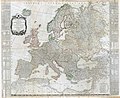 Europe, 1787 (Kitchin).jpg 9,950 × 8,147; 17.44 MB
-
 Map of the Empire of Germany (1782).tif 1,163 × 1,024; 3.41 MB

.jpg)