Category:1810s maps of Maine
Jump to navigation
Jump to search
States of the United States: Alabama · Arizona · Arkansas · California · Delaware · Florida · Georgia · Illinois · Indiana · Iowa · Kentucky · Louisiana · Maine · Maryland · Massachusetts · Michigan · Mississippi · Missouri · New Hampshire · New Jersey · New Mexico · New York · North Carolina · Ohio · Oregon · Pennsylvania · Rhode Island · South Carolina · Tennessee · Texas · Virginia – Washington, D.C.
Puerto Rico
Puerto Rico
Media in category "1810s maps of Maine"
The following 3 files are in this category, out of 3 total.
-
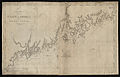 A chart of the coast of America from Wood Island to Good Harbor (3046378936).jpg 2,000 × 1,284; 2.29 MB
-

-

.jpg)
.jpg)
.jpg)