Category:1827 maps of the United States
Jump to navigation
Jump to search
Countries of the Americas: Canada · United States of America
States of the United States: Louisiana · Massachusetts · Michigan · New Jersey · New York · Ohio · Pennsylvania · Vermont
Subcategories
This category has the following 8 subcategories, out of 8 total.
L
- 1827 maps of Louisiana (2 F)
M
- 1827 maps of Massachusetts (3 F)
- 1827 maps of Michigan (1 F)
N
- 1827 maps of New Jersey (3 F)
O
- 1827 maps of Ohio (1 F)
P
- 1827 maps of Pennsylvania (3 F)
V
- 1827 maps of Vermont (1 F)
Media in category "1827 maps of the United States"
The following 29 files are in this category, out of 29 total.
-
 1827 Finley Map of Alabama - Geographicus - Alabama-finley-1827.jpg 2,322 × 3,000; 1.82 MB
-
 1827 Finley Map of Connecticut - Geographicus - Connecticut-finley-1827.jpg 3,000 × 2,348; 2.01 MB
-
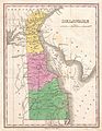 1827 Finley Map of Delaware - Geographicus - Delaware-finley-1827.jpg 2,323 × 3,000; 1.66 MB
-
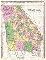 1827 Finley Map of Georgia - Geographicus - Georgia-finley-1827.jpg 2,313 × 3,000; 1.78 MB
-
 1827 Finley Map of Kentucky - Geographicus - Kentucky-finley-1827.jpg 3,000 × 2,355; 1.59 MB
-
 1827 Finley Map of Maine - Geographicus - Maine-finley-1827.jpg 2,323 × 3,000; 1.7 MB
-
 1827 Finley Map of Maryland - Geographicus - Maryland-finley-1827.jpg 3,000 × 2,341; 1.7 MB
-
 1827 Finley Map of Mississippi - Geographicus - Mississippi-finley-1827.jpg 2,281 × 3,000; 1.64 MB
-
 1827 Finley Map of Missouri - Geographicus - Missouri-finley-1827.jpg 2,337 × 3,000; 1.66 MB
-
 1827 Finley Map of New Hampshire - Geographicus - NewHampshire-finely-1827.jpg 2,339 × 3,000; 1.63 MB
-
 1827 Finley Map of New Jersey - Geographicus - NewJersey-finley-1827.jpg 2,297 × 3,000; 1.72 MB
-
 1827 Finley Map of North Carolina - Geographicus - NorthCarolina-finley-1827.jpg 3,000 × 2,344; 1.71 MB
-
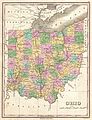 1827 Finley Map of Ohio - Geographicus - Ohio-finley-1827.jpg 2,308 × 3,000; 1.95 MB
-
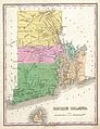 1827 Finley Map of Rhode Island - Geographicus - RhodeIsland-finley-1827.jpg 2,314 × 3,000; 1.67 MB
-
 1827 Finley Map of South Carolina - Geographicus - SouthCarolina-finley-1827.jpg 3,000 × 2,343; 1.73 MB
-
 1827 Finley Map of Tennessee - Geographicus - Tennessee-finley-1827.jpg 3,000 × 2,279; 1.54 MB
-
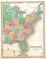 1827 Finley Map of the United States - Geographicus - UnitedStates-finley-1827.jpg 2,339 × 3,000; 1.95 MB
-
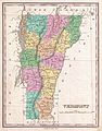 1827 Finley Map of Vermont - Geographicus - Vermont-finely-1827.jpg 2,356 × 3,000; 1.78 MB
-
 1827 Finley Map of Virginia - Geographicus - Virginia-finley-1827.jpg 3,000 × 2,304; 1.84 MB
-
 1827 North Carolina and South Carolina map (Tanner).jpg 9,550 × 7,195; 11.6 MB
-

-

-

-

-

-

-

-
 Map of the United States, constructed from the latest authorities (NYPL b14951584-434645).tiff 6,059 × 4,640; 80.44 MB
-
 Virginia, Maryland, and Delaware - by H.S. Tanner. NYPL434093.tiff 5,020 × 4,027; 57.86 MB


.jpg)


.jpg)