Category:1838 maps of Spain
Jump to navigation
Jump to search
Media in category "1838 maps of Spain"
The following 7 files are in this category, out of 7 total.
-
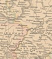 1838 detalle mombuey.jpg 538 × 617; 173 KB
-
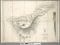 Admiralty Chart No 1870 Tenerife - Canary Islands, Surveyed 1838.jpg 8,197 × 6,225; 14.04 MB
-
-

-

-
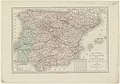
 Spain and Portugal in provinces. 1838. Philip Smith (detalle noroeste).jpg 1,696 × 1,604; 1.56 MB
-
 Zamora y salamanca mapa 1838.jpg 567 × 589; 223 KB


.jpg)
