Category:1839 maps
Jump to navigation
Jump to search
| ← · 1830 · 1831 · 1832 · 1833 · 1834 · 1835 · 1836 · 1837 · 1838 · 1839 · → |
Deutsch: Karten mit Bezug zum Jahr 1839
English: Maps related to the year 1839
Español: Mapas relativos al año 1839
Français : Cartes concernant l’an 1839
Русский: Карты 1839 года
Subcategories
This category has the following 10 subcategories, out of 10 total.
A
- 1839 maps of Africa (9 F)
E
M
- Mitchell's school atlas (35 F)
N
O
- Oberreit, Sect. Oschatz, 1839–40 (116 F)
- 1839 maps of Oceania (1 F)
S
Media in category "1839 maps"
The following 74 files are in this category, out of 74 total.
-
 (1839) PART OF SOUTH AUSTRALIA.jpg 3,079 × 2,413; 2.87 MB
-
 (1839) PLAN OF THE CITY OF ADELAIDE.jpg 2,527 × 3,132; 4.18 MB
-

-

-
 Aqueduc de Fréjus rapport de Louis Just (1839)50.jpg 2,048 × 1,536; 440 KB
-
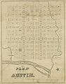 Austin Street Map, 1839.jpg 4,165 × 5,283; 5.03 MB
-
 Baltimore. NYPL433885.tiff 3,503 × 3,553; 35.62 MB
-
 Bookham Lodge Map 1839.jpg 962 × 1,280; 379 KB
-

-

-
 Delta of the Mississippi (2674677478).jpg 1,450 × 2,000; 1.58 MB
-
 Eastern passages to China sheet II LOC 2007628650.jpg 7,739 × 11,561; 9 MB
-
 Eastern passages to China sheet II LOC 2007628650.tif 7,739 × 11,561; 255.98 MB
-
 Egypte Syrie Phoenicie et Asie Mineure (FL37122007 3898271).jpg 3,499 × 5,008; 9.34 MB
-
 Heinrich Karl Wilhelm Berghaus, Part of Arabia Petræa and Palestine (FL17237374 3421439).jpg 2,518 × 4,197; 16.48 MB
-
 Hundreds of Somerset.png 616 × 768; 499 KB
-
 Joseph Salzbacher, Topographischer Plan von Jerusalem (FL184620731 2367919).jpg 3,680 × 4,553; 8.86 MB
-
 Katschina Schloss COSK 1839.jpg 3,000 × 4,000; 4.05 MB
-
 Kingston-road-1839-tn1.gif 534 × 286; 96 KB
-
 KrasnaHora1839.jpg 3,435 × 1,885; 4.13 MB
-
 Loudon-map-1839-tn1.gif 465 × 348; 103 KB
-

-

-
-

-
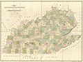
 Map of Kentucky and Tennessee by David H Burr - WDL.png 1,375 × 1,024; 2.2 MB
-

-

-
-

-

-

-

-
 Map of the city and county of New York - with the adjacent country - by David H. Burr. NYPL433789.tiff 5,680 × 11,286; 183.41 MB
-

-

-

-

-

-

-

-

-

-
 Map of the Potomac River from South Lowell to Alexandria with the lateral canals LOC 83694374.tif 7,469 × 4,959; 105.97 MB
-
 Map of Two Hemispheres, 1839, engraved by Kalama and Kepohoni.jpg 400 × 243; 20 KB
-

-

-
 Map of Virginia, Maryland and Delaware WDL9595.png 1,379 × 1,024; 2.38 MB
-
 Mitchell's school atlas LOC 2007633727-4.jpg 2,811 × 3,415; 1.52 MB
-
 Mitchell's school atlas LOC 2007633727-4.tif 2,811 × 3,415; 27.46 MB
-
 Na Mokupuni o Hawaii, 1839, engraved by Kapeau.jpg 2,018 × 1,275; 851 KB
-
 New Jersey - engraved by J.H. Young. NYPL434620.tiff 4,416 × 5,979; 75.55 MB
-
 New-York. NYPL433886.tiff 4,792 × 2,739; 37.57 MB
-
 Nova Hospoda COSK-01.jpg 4,000 × 4,000; 3.57 MB
-
 Nova Hospoda COSK-detail.jpg 4,000 × 3,000; 2.5 MB
-
 Omnibus Kaart of Nieuwe Platte Grond der Stad Amsterdam waarop alle de - no-nb krt 00779.jpg 8,843 × 6,786; 20.59 MB
-
 Palapala Honua, engraved by Kalama and Kepohoni, 1839.jpg 5,320 × 3,328; 6.69 MB
-
 Pianta di Gerusalemme Prima delle Crociate (FL184519951 1004200).jpg 5,327 × 7,547; 41.45 MB
-

-

-

-

-

-
 Self-guide itinerary map of Japan (14803036115).jpg 2,500 × 975; 1.21 MB
-
 StNikolay COSK 1839.jpg 3,000 × 4,000; 2.38 MB
-
 T101.jpg 11,325 × 7,096; 2.76 MB
-
 Upolu map, US Ex. Ex., 1839.jpg 8,102 × 6,041; 7.31 MB
-

-

-
 Wiborg 1839.jpg 7,176 × 5,520; 23.85 MB
-

-

-

-
 William Hughes, The environs of Jerusalem (FL35084310 3890691).jpg 12,127 × 8,159; 131.88 MB
_PART_OF_SOUTH_AUSTRALIA.jpg)
_PLAN_OF_THE_CITY_OF_ADELAIDE.jpg)
50.jpg)


.jpg)

.jpg)
.jpg)

.jpg)


_Geographer_to_the_House_of_Representatives_of_LOC_98688485.jpg)

.jpg)


_reduced_from_the_original_of_Messrs._Featherstonehaugh_%26_Mudge,_British_commissioners_(8346881914).jpg)


.jpg)

.jpg)
.jpg)
.jpg)


.jpg)
.jpg)
.jpg)