Category:1840s maps of Ohio
Jump to navigation
Jump to search
States of the United States: Alabama · Alaska · Arkansas · California · Connecticut · Delaware · Florida · Georgia · Hawaii · Idaho · Illinois · Indiana · Iowa · Kentucky · Louisiana · Maine · Maryland · Massachusetts · Michigan · Minnesota · Mississippi · Missouri · Montana · Nebraska · New Hampshire · New Mexico · New York · North Dakota · Ohio · Oklahoma · Oregon · Pennsylvania · Rhode Island · South Carolina · South Dakota · Tennessee · Texas · Utah · Vermont · Virginia · Washington · Wisconsin · Wyoming – Washington, D.C.
Puerto Rico
Puerto Rico
Subcategories
This category has the following 4 subcategories, out of 4 total.
- 1840 maps of Ohio (2 F)
- 1845 maps of Ohio (3 F)
- 1846 maps of Ohio (2 F)
- 1849 maps of Ohio (1 F)
Media in category "1840s maps of Ohio"
The following 11 files are in this category, out of 11 total.
-

-
 84 of 'Original Contributions to the American Pioneer' (11022135094).jpg 2,528 × 1,522; 840 KB
-
 A map of Fairfield County, Ohio LOC 2012592232.jpg 8,251 × 9,833; 10.94 MB
-
 A map of Fairfield County, Ohio LOC 2012592232.tif 8,251 × 9,833; 232.12 MB
-
 Grimes Village enclosure Squier and Davis Plate XIV Figure 4.jpg 1,000 × 753; 259 KB
-
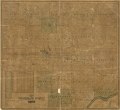
 Map of Columbiana County, Ohio LOC 2012586252.jpg 9,521 × 8,730; 13.76 MB
-
 Map of Columbiana County, Ohio LOC 2012586252.tif 9,521 × 8,730; 237.8 MB
-
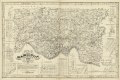
 Map of Delaware County - also a part of Marion and Morrow counties LOC 2012592230.jpg 10,035 × 8,728; 14.78 MB
-
 Map of Delaware County - also a part of Marion and Morrow counties LOC 2012592230.tif 10,035 × 8,728; 250.58 MB
-
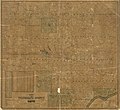
 Map of Hamilton County, Ohio LOC 2012591123.jpg 11,210 × 7,451; 13.25 MB
-
 Map of Hamilton County, Ohio LOC 2012591123.tif 11,210 × 7,451; 238.97 MB
.jpg)
.jpg)


