Category:1872 maps of Michigan
Jump to navigation
Jump to search
States of the United States: California · Illinois · Michigan · New York · Oregon · Pennsylvania · Texas · Utah · Wyoming
| 1871 1872 1873 1874 1875 1876 1877 1878 1879 → |
Subcategories
This category has the following 4 subcategories, out of 4 total.
Media in category "1872 maps of Michigan"
The following 2 files are in this category, out of 2 total.
-
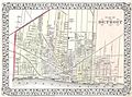 1872 Mitchell Map of the City of Detroit, Michigan - Geographicus - Detroit-m-72.jpg 3,000 × 2,235; 1.68 MB
-
 Birds eye view of Houghton, L.S., Michigan, 1872 (2675796710).jpg 2,000 × 1,517; 3.04 MB

.jpg)