Category:1873 maps of New Jersey
Jump to navigation
Jump to search
States of the United States: California · Hawaii · Illinois · Louisiana · Michigan · New Jersey · New Mexico · New York · Ohio · Pennsylvania · West Virginia
| 1870 1873 1875 1876 → |
Subcategories
This category has only the following subcategory.
Media in category "1873 maps of New Jersey"
The following 53 files are in this category, out of 53 total.
-
 1873AtlanticCountyMapByGMHopkins.png 2,179 × 2,693; 4.32 MB
-
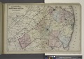
 62 of 'Popular Resorts and how to reach them, etc. (Second edition.)' (11251378074).jpg 1,045 × 1,833; 495 KB
-

-

-
 Annandale (Village); Pittstown (Village); Quakertown (Village) NYPL1602723.tiff 4,104 × 5,268; 61.86 MB
-
 Asbury (Village); Bloomsbury (Village) NYPL1602714.tiff 4,407 × 5,709; 71.98 MB
-
 Atlas of Hunterdon County, New Jersey NYPL1602703.tiff 5,428 × 7,230; 112.28 MB
-
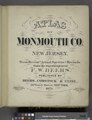 Atlas of Monmouth co., New Jersey. NYPL1603088.tiff 5,428 × 7,052; 109.52 MB
-
 Atlas of New Jersey - Counties of Essex, Union, and Hudson. NYPL1692351.tiff 7,230 × 5,428; 112.28 MB
-

-

-
 Branchburg (Village); Ocean Township Business Notices.; Oceanville (Village) NYPL1603081.tiff 5,428 × 7,052; 109.52 MB
-
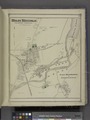
 Branchport (Village) NYPL1603090.tiff 7,052 × 5,428; 109.52 MB
-
 Clinton (Village); Clinton Business Notices. NYPL1602722.tiff 5,205 × 4,228; 62.96 MB
-

-
 East Amwell (Township); Wertsville (Village) NYPL1602735.tiff 5,474 × 4,484; 70.23 MB
-
 Eatontown Business Notices.; Eatontown (Village) NYPL1603080.tiff 7,230 × 5,100; 105.5 MB
-
 Fair View Cemetery (Village) NYPL1603082.tiff 5,428 × 7,052; 109.52 MB
-
 Flemington (Village); Flemington Business Notices. NYPL1602729.tiff 5,404 × 6,270; 96.94 MB
-
 High Bridge (Township); High Bridge Business Notices.; Mountainville (Village) NYPL1602715.tiff 5,428 × 7,230; 112.28 MB
-
 High Bridge (Village); East High Bridge or Everettsville. (Village) NYPL1602716.tiff 5,428 × 7,230; 112.28 MB
-

-

-
 Holmdel Business Directory.; Holmdel (Township) NYPL1603073.tiff 5,428 × 7,052; 109.52 MB
-
 Howell (Township) NYPL1603098.tiff 5,428 × 7,052; 109.52 MB
-

-
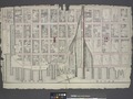 Jersey City Pier. NYPL1692350.tiff 7,230 × 5,428; 112.28 MB
-
 Jersey City. NYPL1692349.tiff 7,230 × 5,428; 112.3 MB
-
 Keyport (Village); Keyport Business Notices. NYPL1603071.tiff 6,450 × 5,428; 100.17 MB
-
-
 North Part of Lambertville (Village) NYPL1602733.tiff 7,230 × 4,904; 101.44 MB
-
 Raritan (Township) NYPL1602728.tiff 5,489 × 4,503; 70.72 MB
-
 Raritan (Township) NYPL1603070.tiff 7,052 × 5,428; 109.52 MB
-
 Readington (Township) NYPL1602724.tiff 4,904 × 7,230; 101.44 MB
-
 Redbank Business Directory.; Redbank (Village) NYPL1603078.tiff 5,428 × 6,982; 108.43 MB
-
 Seabright and Monmouth Beach Property (Villages) NYPL1603086.tiff 5,428 × 7,052; 109.52 MB
-
 South Part of Lambertville (Village) NYPL1602734.tiff 7,230 × 4,904; 101.44 MB
-

-

-
 Table of Contents. NYPL1602704.tiff 5,428 × 7,230; 112.28 MB
-
 Table of Contents. NYPL1603089.tiff 5,428 × 7,052; 109.52 MB
-
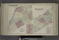
 Tewksbury (Township) NYPL1602717.tiff 4,489 × 5,449; 69.98 MB
-
 The Census of the State of New Jersey, for 1870. (cont.) NYPL1602707.tiff 5,428 × 7,230; 112.28 MB
-
 The Census of the State of New Jersey, for 1870. NYPL1602706.tiff 5,428 × 7,230; 112.28 MB
-
 The Census of the States of New Jersey, for 1870. (cont.) NYPL1603065.tiff 5,428 × 7,052; 109.52 MB
-
 The Census of the States of New Jersey, for 1870. NYPL1603064.tiff 5,428 × 7,052; 109.52 MB
-

-
 Topographical Map of Monmouth Co., New Jersey. NYPL1603067.tiff 7,230 × 5,100; 105.5 MB
-
 Town of Freehold (Village) NYPL1603102.tiff 5,428 × 6,938; 107.75 MB
-
 Upper Freehold (Township) NYPL1603106.tiff 5,428 × 7,052; 109.52 MB
-

-

-


%27_(11251378074).jpg)