Category:1879 maps of New York (state)
Jump to navigation
Jump to search
Subcategories
This category has only the following subcategory.
N
Media in category "1879 maps of New York (state)"
The following 13 files are in this category, out of 13 total.
-
 Albany, New York (2675099920).jpg 2,000 × 1,288; 2.03 MB
-
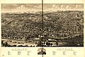 Albany, New York 1879. LOC 75694743.jpg 13,824 × 9,360; 21.94 MB
-
 Cohoes, N.Y. (2675026355).jpg 2,000 × 1,477; 2.65 MB
-
 Frank Tweedy Map of Beaver Lake for Adirondack Survey.jpg 9,284 × 7,487; 10.51 MB
-
 Map of Coney Island and Sheepshead Bay, New York - NARA - 6281631.jpg 3,150 × 741; 625 KB
-
 Map of the Allegany County oil field - from surveys and official records LOC 2012593646.jpg 10,721 × 8,035; 11.6 MB
-
 Map of the Allegany County oil field - from surveys and official records LOC 2012593646.tif 10,721 × 8,035; 246.46 MB
-
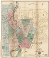
 Map of the city of Rochester LOC 2011593646.jpg 6,263 × 7,338; 7.15 MB
-
 Map of the city of Rochester LOC 2011593646.tif 6,263 × 7,338; 131.49 MB
-
 Map of the town of Saratoga Springs, Saratoga Co., N.Y. LOC 00561206.jpg 15,600 × 10,555; 16.93 MB
-
 Map of the town of Saratoga Springs, Saratoga Co., N.Y. LOC 00561206.tif 15,600 × 10,555; 471.09 MB
-

-

.jpg)

.jpg)


