Category:1880s maps of Vienna
Jump to navigation
Jump to search
Subcategories
This category has only the following subcategory.
Media in category "1880s maps of Vienna"
The following 16 files are in this category, out of 16 total.
-
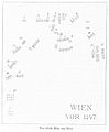 BERMANN(1880) p0128 Der älteste (bekannte) Plan von Wien.jpg 702 × 853; 208 KB
-
 BERMANN(1880) p0136 Plan von Wien, um 1170.jpg 844 × 584; 328 KB
-
 BERMANN(1880) p0171 Wien um 1210.jpg 841 × 662; 371 KB
-

-
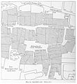 BERMANN(1880) p0514 Das Stadtquartier der Wiener Juden.jpg 802 × 876; 453 KB
-
 BERMANN(1880) p0547 Plan von Wien um 1440.jpg 900 × 622; 281 KB
-
 BERMANN(1880) p0794 Plan von Wien von A.Hirschvogel, 1547.jpg 892 × 878; 542 KB
-
 Plan - von Wien mit Vororten und nächster Umgebung - btv1b53057725w.jpg 7,609 × 5,939; 8.93 MB
-
 453 of 'Neue Folge' (11191767706).jpg 2,921 × 3,676; 1.55 MB
-
 Orientinungs und Strassen Plan Wien, mit Vororten - btv1b53025041n (01 of 26).jpg 8,852 × 8,486; 13.79 MB
-
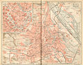 Meyers b16 s0600a.jpg 800 × 628; 236 KB
-
 Umgebung von Wien (Einseitige Farbkarte).jpg 800 × 1,236; 451 KB
-
 Wien aus der Vogelschau - btv1b53025172q.jpg 13,889 × 8,046; 17.86 MB
-
 Neu-Lerchenfeld-1883.png 1,560 × 2,292; 1.66 MB
-
 The earth and its inhabitants (1883) (21136459651).jpg 2,972 × 1,960; 1.88 MB
-
 Wien-Metropolitanbahn-etv.-Schlachthofbahn-(1882).gif 4,631 × 3,942; 13.98 MB
_p0128_Der_%C3%A4lteste_(bekannte)_Plan_von_Wien.jpg)
_p0136_Plan_von_Wien,_um_1170.jpg)
_p0171_Wien_um_1210.jpg)
_p0455_Plan_der_Wiener_Universit%C3%A4t_und_Studentenquartiere.jpg)
_p0514_Das_Stadtquartier_der_Wiener_Juden.jpg)
_p0547_Plan_von_Wien_um_1440.jpg)
_p0794_Plan_von_Wien_von_A.Hirschvogel,_1547.jpg)

.jpg)
.jpg)

.jpg)


_(21136459651).jpg)
.gif)