Category:1886 maps
Jump to navigation
Jump to search
| ← · 1880 · 1881 · 1882 · 1883 · 1884 · 1885 · 1886 · 1887 · 1888 · 1889 · → |
Deutsch: Karten mit Bezug zum Jahr 1886
English: Maps related to the year 1886
Español: Mapas relativos al año 1886
Français : Cartes concernant l’an 1886
Русский: Карты 1886 года
Subcategories
This category has the following 12 subcategories, out of 12 total.
Media in category "1886 maps"
The following 113 files are in this category, out of 113 total.
-
 N.N.(1886) p103 Pola in der Römerzeit.jpg 3,607 × 4,393; 3.41 MB
-
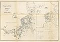 N.N.(1886) p107 Pola, Stadtplan.jpg 6,645 × 4,685; 5.54 MB
-
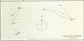
 SARMATICUS(1886) p078 BERESINA UND OBERER DNJEPR - (Skizze 8).jpg 1,756 × 2,609; 489 KB
-
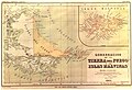
 British Empire map - The India and Colonial Exhibition, London (1886) - BL.jpg 1,680 × 1,346; 974 KB
-

-
 1886 D&H.jpg 1,728 × 2,040; 285 KB
-

-

-
 1886 map - Atlas des ports étrangers.pdf 1,514 × 1,962, 53 pages; 79.74 MB
-
 1886 SouthBoston map byBromley BPL 12259 detail.png 1,210 × 610; 1.33 MB
-
 1886 Spanish nautical map of Elato and Lamotrek.jpg 3,535 × 1,733; 429 KB
-
 1886 Spanish nautical map of Federated States of Micronesia islands.jpg 4,584 × 5,412; 1.63 MB
-
 1886 Spanish nautical map of Olimarao.jpg 995 × 1,179; 108 KB
-
 1886 Spanish nautical map of Pikelot.jpg 867 × 1,171; 89 KB
-
 1886 Spanish nautical map of West Fayu.jpg 1,711 × 1,183; 159 KB
-
 1886 Spanish nautical map of Woleai Atoll.jpg 3,543 × 2,141; 716 KB
-
 1886 Telescopic View and Map of the Moon - Geographicus - Moon-unknown-1886.jpg 3,500 × 4,950; 3.27 MB
-
 1886rail-usgenweb-mapproject.jpg 1,772 × 2,092; 1.16 MB
-

-
 Anales de la Sociedad Espala de Historia Natural (1886) (17543540604).jpg 2,576 × 1,530; 578 KB
-

-

-
 Anpen-fu yori Keijō ni itaru rojōzu LOC 2008486378.jpg 12,153 × 8,165; 10.3 MB
-
 Anpen-fu yori Keijō ni itaru rojōzu LOC 2008486378.tif 12,153 × 8,165; 283.9 MB
-
 Aqua traiana planlatium.jpg 2,734 × 2,099; 2.64 MB
-

-
 Balkans in 1350 according to Gustav Droysen from 19th century.jpg 1,367 × 1,268; 546 KB
-
 British empire 1886.jpg 1,500 × 1,122; 625 KB
-
 Bulletin (1886) (20232450568).jpg 3,714 × 1,900; 1.3 MB
-
-

-

-
 Colton's Delaware, Maryland, Virginia and West Virginia. LOC gm69002312.jpg 8,208 × 5,336; 8.84 MB
-
 Colton's Delaware, Maryland, Virginia and West Virginia. LOC gm69002312.tif 8,208 × 5,336; 125.31 MB
-
 Denver and Rio Grande Railway System, 1886. LOC 98688651.jpg 5,489 × 4,459; 5.71 MB
-
 Denver and Rio Grande Railway System, 1886. LOC 98688651.tif 5,489 × 4,459; 70.03 MB
-
 Droysens-28a.jpg 1,631 × 1,654; 4.65 MB
-
 EB9 Saratoga Springs.jpg 845 × 850; 209 KB
-
 EB9 Scarborough - plan.jpg 1,159 × 1,542; 819 KB
-
 EB9 St Paul.jpg 837 × 575; 165 KB
-
 Elsass-Lothringen 1648-1789.jpg 1,456 × 2,332; 2.29 MB
-
 Flammarion - La planète Mars, Tome 2-f024.jpg 584 × 584; 62 KB
-
 General Buell's map of the battle-field of Shiloh. (April 6-7, 1862) LOC 99448855.jpg 6,386 × 5,389; 7.06 MB
-
 General Buell's map of the battle-field of Shiloh. (April 6-7, 1862) LOC 99448855.tif 6,386 × 5,389; 98.46 MB
-

-
 Germania Magna nach Ptolemaeus.jpg 666 × 748; 178 KB
-

-
 Hanoi quartier administratif petit lac map plan 1886.jpg 845 × 960; 490 KB
-
 Henri Nicole, Plan topographique de Jerusalem et de ses environs (FL6880591 2368140).jpg 2,100 × 2,738; 3.42 MB
-
 Isla Pikelot o Coquille (1886).jpg 852 × 1,169; 352 KB
-
 Keijō yori Genzanshin ni itaru rojōzu LOC 2008486377.jpg 5,856 × 7,961; 5.12 MB
-
 Keijō yori Genzanshin ni itaru rojōzu LOC 2008486377.tif 5,856 × 7,961; 133.38 MB
-
 Kyzer's complete map of Cleveland County, N.C. - 1886 LOC 2012593701.jpg 6,626 × 7,453; 9.72 MB
-
 Kyzer's complete map of Cleveland County, N.C. - 1886 LOC 2012593701.tif 6,626 × 7,453; 141.29 MB
-

-
 Map of Brown County, Minn. - from personal examination and public records. LOC 2012593032.jpg 18,652 × 13,761; 28.26 MB
-
 Map of Brown County, Minn. - from personal examination and public records. LOC 2012593032.tif 18,652 × 13,761; 734.34 MB
-
 Map of Catawba County, North Carolina. LOC 2001620490.jpg 17,048 × 10,045; 23.62 MB
-
 Map of Great Kanawha coal field showing location of mines. LOC 00556411.jpg 1,227 × 3,050; 739 KB
-
 Map of Great Kanawha coal field showing location of mines. LOC 00556411.tif 1,227 × 3,050; 10.71 MB
-

-

-
 Map of the city of San Jose LOC 2012593206.jpg 12,175 × 10,981; 15.75 MB
-

-

-
 MapG basserman land.jpg 684 × 1,052; 330 KB
-
 Marea Neagra nord-vest 1886.JPG 4,805 × 2,660; 3.86 MB
-
 Maryland-District of Columbia-Virginia, Washington sheet LOC 94684037.jpg 9,404 × 6,168; 10.8 MB
-
 Maryland-District of Columbia-Virginia, Washington sheet LOC 94684037.tif 9,404 × 6,168; 165.95 MB
-
 OberamtEllwangen Karte.jpg 10,360 × 7,773; 19.76 MB
-

-

-
 Old Stratfield (Bridgeport) Map before 1886.jpg 1,851 × 2,267; 325 KB
-
 Palestine in the time of our saviour (FL35098638 3892362).jpg 12,624 × 14,872; 269.53 MB
-
 Piano di insieme.jpg 1,909 × 1,415; 3.38 MB
-

-

-
 PSM V28 D451 Hell gate new york.jpg 2,214 × 1,704; 410 KB
-
 PSM V28 D454 Hallet point excavations and tunnel 7.jpg 1,515 × 1,542; 343 KB
-
 PSM V28 D456 Plan of excavations of flood rock.jpg 2,865 × 1,568; 853 KB
-
 Rail line map of the Los Angeles and San Gabriel Valley Railroad.jpg 400 × 300; 16 KB
-

-

-
 Roumanie (1886).jpg 4,288 × 3,268; 3.24 MB
-
 Röthenbach LOC 2008621300.jpg 5,893 × 4,677; 3.35 MB
-
 Röthenbach LOC 2008621300.tif 5,893 × 4,677; 78.85 MB
-
 Sanborn Fire Insurance Map from Jamestown, Mercer County, Pennsylvania. LOC sanborn07735 001.tif 6,450 × 7,650; 141.17 MB
-

-
 Sanborn Fire Insurance Map from Le Roy, Mower County, Minnesota. LOC sanborn04326 001.tif 6,450 × 7,650; 141.17 MB
-

-
 Sanborn Fire Insurance Map from McAlester, Pittsburg County, Oklahoma. LOC sanborn07162 001.tif 6,450 × 7,650; 141.17 MB
-

-
 Sanborn Fire Insurance Map from Muskogee, Muskogee County, Oklahoma. LOC sanborn07189 001.tif 6,450 × 7,650; 141.17 MB
-
 Sanborn Fire Insurance Map from Ocala, Marion County, Florida. LOC sanborn01319 002.jpg 6,450 × 7,650; 3.89 MB
-
 Sanborn Fire Insurance Map from Ocala, Marion County, Florida. LOC sanborn01319 002.tif 6,450 × 7,650; 141.17 MB
-

-
 Sanborn Fire Insurance Map from Portland, Traill County, North Dakota. LOC sanborn06563 001.tif 6,510 × 7,707; 143.55 MB
-

-
 Sanborn Fire Insurance Map from Sheldon, Ransom County, North Dakota. LOC sanborn06567 001.tif 6,510 × 7,707; 143.55 MB
-
 Sanborn Fire Insurance Map from Tuscarora, Elko County, Nevada. LOC sanborn05297 001.jpg 6,510 × 7,680; 3.04 MB
-
 Sanborn Fire Insurance Map from Tuscarora, Elko County, Nevada. LOC sanborn05297 001.tif 6,510 × 7,680; 143.04 MB
-
 Sanborn Fire Insurance Map from Vinita, Craig County, Oklahoma. LOC sanborn07285 001.jpg 6,450 × 7,650; 3.74 MB
-
 Section de Tsong-Ming, 1885-86 - Mission de Nanking - btv1b53070043c.jpg 6,467 × 8,310; 5.69 MB
-
 Seelstrang1886.jpg 4,954 × 3,368; 10.6 MB
-
 Sierck-1661.png 152 × 219; 91 KB
-
 Sierre LOC 2007632857.jpg 5,890 × 4,450; 3.7 MB
-
 Sierre LOC 2007632857.tif 5,890 × 4,450; 74.99 MB
-

-

-
 The American journal of science (1886) (17529928293).jpg 2,704 × 1,426; 1.15 MB
-
 Umgebungskarte der österr. arctischen Beobachtungsstation Wilczek-Thal auf Jan Mayen.jpg 9,152 × 4,400; 15.07 MB
-
 Venice WDL411.png 1,452 × 1,024; 3.02 MB
-
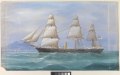 Volage RMG PW8166.tiff 4,800 × 3,025; 41.54 MB
_p103_Pola_in_der_R%C3%B6merzeit.jpg)
_p107_Pola,_Stadtplan.jpg)
_p078_BERESINA_UND_OBERER_DNJEPR_-_(Skizze_8).jpg)
_-_BL.jpg)


.jpg)
_(17543540604).jpg)
_(18741419123).jpg)
_(18741438153).jpg)


_(20232450568).jpg)
_-_official_catalogue_(1886)_(20589227886).jpg)
_-_official_catalogue_(1886)_(20606423972).jpg)
_-_official_catalogue_(1886)_(20622097881).jpg)


_LOC_99448855.jpg)
.jpg)

_from_the_survey_of_Gottlieb_Schumacher,_C.E_(FL45611999_3954731).jpg)

.jpg)
.jpg)


_Map_before_1886.jpg)
.jpg)

.jpg)


.jpg)


_(17529928293).jpg)


.jpg)