Category:1891 maps of Montana
Jump to navigation
Jump to search
States of the United States: California · Connecticut · Delaware · Florida · Idaho · Illinois · Iowa · Kansas · Louisiana · Maryland · Massachusetts · Michigan · Minnesota · Missouri · Montana · New Jersey · New York · North Carolina · Ohio · Oklahoma · Oregon · Pennsylvania · South Dakota · Tennessee · Texas · Utah · Virginia · Washington · Wisconsin · Wyoming – Washington, D.C.
| ← 1890 1891 1892 1893 1894 1896 1897 1898 1899 |
Subcategories
This category has the following 5 subcategories, out of 5 total.
Media in category "1891 maps of Montana"
The following 39 files are in this category, out of 39 total.
-
-
 Sanborn Fire Insurance Map from Belgrade, Gallatin County, Montana. LOC sanborn04934 001.jpg 6,450 × 7,650; 2.94 MB
-
 Sanborn Fire Insurance Map from Belgrade, Gallatin County, Montana. LOC sanborn04934 001.tif 6,450 × 7,650; 141.17 MB
-

-
 Sanborn Fire Insurance Map from Big Timber, Sweet Grass County, Montana. LOC sanborn04938 001.tif 6,450 × 7,650; 141.17 MB
-

-
 Sanborn Fire Insurance Map from Billings, Yellowstone County, Montana. LOC sanborn04939 004-1.tif 6,450 × 7,650; 141.17 MB
-

-
 Sanborn Fire Insurance Map from Billings, Yellowstone County, Montana. LOC sanborn04939 004-2.tif 6,450 × 7,650; 141.17 MB
-

-
 Sanborn Fire Insurance Map from Billings, Yellowstone County, Montana. LOC sanborn04939 004-3.tif 6,450 × 7,650; 141.17 MB
-

-
 Sanborn Fire Insurance Map from Billings, Yellowstone County, Montana. LOC sanborn04939 004-4.tif 6,450 × 7,650; 141.17 MB
-
-
 Sanborn Fire Insurance Map from Billings, Yellowstone County, Montana. LOC sanborn04939 004-5.tif 6,450 × 7,650; 141.17 MB
-

-
 Sanborn Fire Insurance Map from Billings, Yellowstone County, Montana. LOC sanborn04939 004-6.tif 6,450 × 7,650; 141.17 MB
-

-
 Sanborn Fire Insurance Map from Glendale, Beaverhead County, Montana. LOC sanborn05004 001.tiff 6,450 × 7,650; 141.17 MB
-
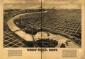
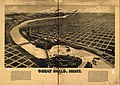 Perspective map of Great Falls, Mont. 1891. LOC 75694668.jpg 10,688 × 7,552; 15.61 MB
-
 Perspective map of Great Falls, Mont. 1891. LOC 75694668.tif 10,688 × 7,552; 230.93 MB
-
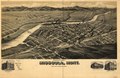
 Perspective map of Missoula, Mont. county seat of Missoula County. LOC 75694674.jpg 10,368 × 6,784; 13.47 MB
-
 Perspective map of Missoula, Mont. county seat of Missoula County. LOC 75694674.tif 10,368 × 6,784; 201.23 MB
-

-
 Sanborn Fire Insurance Map from Sun River City, Cascade County, Montana. LOC sanborn05104 003.tif 6,450 × 7,650; 141.17 MB
-

-
 Sanborn Fire Insurance Map from Townsend, Broadwater County, Montana. LOC sanborn05111 004.tif 6,450 × 7,650; 141.17 MB
-

-

-

-

-

-

-

-

-

-

-

-


