Category:18th-century maps of Barbados
Jump to navigation
Jump to search
Countries of North America: Antigua and Barbuda · The Bahamas · Barbados · Belize · Canada · Costa Rica · Cuba · Guatemala · Haiti · Honduras · Jamaica · Mexico · Nicaragua · Panama · Saint Kitts and Nevis · Saint Vincent and the Grenadines · Trinidad and Tobago‡ · United States of America‡
Other territories: Bermuda · Greenland · Guadeloupe · Martinique · Puerto Rico
‡: partly located in North America
Other territories: Bermuda · Greenland · Guadeloupe · Martinique · Puerto Rico
‡: partly located in North America
Subcategories
This category has the following 3 subcategories, out of 3 total.
1
- 1736 maps of Barbados (2 F)
- 1775 maps of Barbados (3 F)
Media in category "18th-century maps of Barbados"
The following 30 files are in this category, out of 30 total.
-
 The Iland of Babados; Island of Bermuda (NYPL b13909432-1640615).jpg 5,758 × 4,755; 6.14 MB
-
-
 La Barbade une des Antilles aux Anglois, divisée par paroisses. LOC 74691675.jpg 3,670 × 3,476; 1.56 MB
-
 La Barbade une des Antilles aux Anglois, divisée par paroisses. LOC 74691675.tif 3,670 × 3,476; 36.5 MB
-

-

-

-

-

-
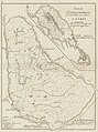
 An accurate map of the island of Barbadoes LOC 95684860.jpg 5,462 × 4,758; 4.33 MB
-
 Barbados (9492653669).jpg 526 × 800; 104 KB
-

-

-
 Carte de l'isle de la Barbade. LOC 73697230.jpg 2,097 × 3,250; 835 KB
-

-

-

-

-

-

-

-
 Les principales forteresses, ports &c. de lAmérique septentrionale (4071869633).jpg 8,936 × 7,408; 10.23 MB
-
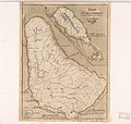
 Map of the Island of Barbados (1742).jpg 1,792 × 1,619; 2.46 MB
-
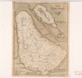
 Moll - The Island of Barbados.png 5,065 × 3,881; 43.44 MB
-

-

-
 Plan de l'isle de la Barbade - (par Labat) - btv1b8596367v.jpg 2,749 × 2,539; 1.08 MB
-
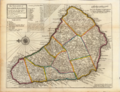
 Plans des isles, rades, et ports de plusieurs lieux de lAmérique (4579410398).jpg 8,568 × 6,104; 14.15 MB
-
 Rigobert-Bonne-Atlas-de-toutes-les-parties-connues-du-globe-terrestre MG 0018.tif 3,536 × 5,263; 53.28 MB
-
 The Iland of Babados; Island of Bermuda. NYPL1640615.tiff 7,230 × 5,428; 112.28 MB
.jpg)
.jpg)


.jpg)
.jpg)


.jpg)

.jpg)


.jpg)
.jpg)

.jpg)
.jpg)
_-_btv1b8596367v.jpg)
.jpg)