Category:1901 maps of Texas
Jump to navigation
Jump to search
States of the United States: California · Hawaii · Idaho · Illinois · Iowa · Kansas · Maryland · Massachusetts · Michigan · Minnesota · New York · North Dakota · Oklahoma · Pennsylvania · Texas · Vermont · Virginia · Wisconsin – Washington, D.C.
| ← 1900 1901 1902 1904 1905 1907 1908 1909 → |
Media in category "1901 maps of Texas"
The following 6 files are in this category, out of 6 total.
-
-
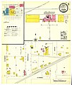
 Sanborn Fire Insurance Map from Athens, Henderson County, Texas. LOC sanborn08413 004-1.tif 6,674 × 7,826; 149.43 MB
-
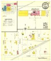
 Sanborn Fire Insurance Map from Athens, Henderson County, Texas. LOC sanborn08413 004-2.jpg 6,610 × 7,818; 2.78 MB
-
 Sanborn Fire Insurance Map from Athens, Henderson County, Texas. LOC sanborn08413 004-2.tif 6,610 × 7,818; 147.85 MB
-
 Sanborn Fire Insurance Map from Athens, Henderson County, Texas. LOC sanborn08413 004-3.jpg 6,589 × 7,829; 2.47 MB
-
 Sanborn Fire Insurance Map from Athens, Henderson County, Texas. LOC sanborn08413 004-3.tif 6,589 × 7,829; 147.59 MB


