Category:1913 maps of Wisconsin
Jump to navigation
Jump to search
States of the United States: California · Florida · Georgia · Hawaii · Idaho · Illinois · Iowa · Louisiana · Maryland · Michigan · Minnesota · Missouri · New York · North Dakota · Ohio · Oklahoma · Pennsylvania · South Carolina · Utah · West Virginia · Wisconsin – Washington, D.C.
| ← 1910 1911 1912 1913 1914 1915 1916 1917 1918 1919 → |
Subcategories
This category has the following 7 subcategories, out of 7 total.
S
Media in category "1913 maps of Wisconsin"
The following 6 files are in this category, out of 6 total.
-
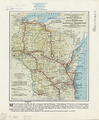 National Highways Map of the State of Wisconsin WDL11539.png 1,024 × 1,242; 2.28 MB
-
-
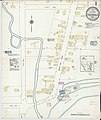
 Sanborn Fire Insurance Map from Thiensville, Ozaukee County, Wisconsin. LOC sanborn09712 003-1.tif 6,450 × 7,650; 141.17 MB
-

-
 Sanborn Fire Insurance Map from Thiensville, Ozaukee County, Wisconsin. LOC sanborn09712 003-2.tif 6,450 × 7,650; 141.17 MB
-
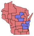 WI Senate Partisan Map 1913.svg 245 × 262; 51 KB


