Category:1920s maps of London
Jump to navigation
Jump to search
Subcategories
This category has only the following subcategory.
B
- Bacon's Pocket Atlas of London (49 F)
Media in category "1920s maps of London"
The following 10 files are in this category, out of 10 total.
-
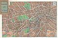
 1920 Bacon Pocket Map of London, England and Environs - Geographicus - London-bacon-1920.jpg 5,000 × 3,651; 6.14 MB
-

-
 A1 in London 1923.jpg 289 × 424; 55 KB
-
-
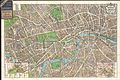 1924 Geographia Pictorial Map of London, England - Geographicus - London-geographia-1924.jpg 5,000 × 3,350; 6.89 MB
-

-
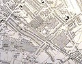
 Craigmar map.jpg 2,279 × 1,546; 2.37 MB
-
 Map of Claigmar Vineyard 1920.jpg 1,569 × 1,234; 1.34 MB
-
 Ordnance Survey One-Inch Sheet 107 London NE & Epping Forest, Published 1920.jpg 11,844 × 8,546; 12.67 MB
-
 Ordnance Survey One-Inch Tourist Map of Country Round London, Published 1921.jpg 15,484 × 12,002; 27.13 MB


