Category:1946 in Suffolk
Jump to navigation
Jump to search
Ceremonial counties of England: Cambridgeshire · Cornwall · Derbyshire · East Riding of Yorkshire · Gloucestershire · Greater London · Hampshire · Kent · Lancashire · Lincolnshire · Norfolk · Suffolk · West Sussex · Wiltshire ·
City-counties:
Former historic counties:
Other former counties:
City-counties:
Former historic counties:
Other former counties:
Media in category "1946 in Suffolk"
The following 27 files are in this category, out of 27 total.
-
 Belstead Map 1946.png 573 × 443; 464 KB
-
 Map of Bentley, Suffolk, OS 1946.png 359 × 341; 206 KB
-
 Map of Brantham, OS 1946.png 396 × 270; 193 KB
-
 Map of Burstall, OS 1946.png 217 × 177; 77 KB
-
 Map of Capel St Mary, OS 1946.png 183 × 113; 37 KB
-
 Map of Chattisham, OS 1946.png 176 × 119; 35 KB
-
 Map of Chelmondiston, OS 1946.png 313 × 219; 123 KB
-
 Map of Copdock, OS 1946.png 176 × 134; 46 KB
-
 Map of East Bergholt, OS 1946.png 260 × 202; 114 KB
-
 Map of Erwarton, OS 1946.png 188 × 147; 43 KB
-
 Map of Freston, OS 1946.png 235 × 146; 66 KB
-
 Map of Great Wenham, OS 1946.png 198 × 147; 47 KB
-
 Map of Harkstead, OS 1946.png 231 × 151; 64 KB
-
 Map of Higham, Babergh OS 1946.png 276 × 183; 105 KB
-
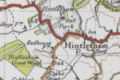 Map of Hintlesham, OS 1946.png 290 × 194; 111 KB
-
 Map of Holbrook, OS 1946.png 387 × 272; 202 KB
-
 Map of Raydon, OS 1946.png 259 × 168; 84 KB
-
 Map of Shelley, Suffolk, OS 1946.png 290 × 178; 97 KB
-
 Map of Shotley, OS 1946.png 333 × 231; 133 KB
-
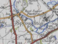 Map of Sproughton, OS 1946.png 251 × 192; 98 KB
-
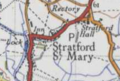 Map of Stratford St Mary, OS 1946.png 214 × 144; 65 KB
-
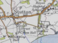 Map of Stutton, OS 1946.png 259 × 195; 91 KB
-
 Map of Tattingstone, OS 1946.png 328 × 231; 138 KB
-
 Map of Washbrook, OS 1946.png 224 × 138; 64 KB
-
 Map of Whearsted, OS 1946.png 328 × 279; 184 KB
-
 Map of Woolverstone, OS 1946.png 344 × 205; 130 KB
-
 Ordnance Survey One-Inch Sheet 136 Bury St Edmunds, Published 1946.jpg 8,223 × 9,614; 9.99 MB


