Category:1948 United States gubernatorial election maps
Jump to navigation
Jump to search
Media in category "1948 United States gubernatorial election maps"
The following 36 files are in this category, out of 36 total.
-
 1948 Colorado gubernatorial election results map by county.svg 810 × 589; 36 KB
-
 1948 Connecticut gubernatorial election results map by county.svg 810 × 595; 22 KB
-
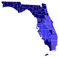 1948 Florida gubernatorial election results map by county.svg 744 × 727; 423 KB
-

-
 1948 Illinois gubernatorial election results map by county.svg 810 × 810; 43 KB
-
 1948 Indiana gubernatorial election results map by county.svg 810 × 810; 35 KB
-
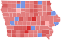 1948 Iowa gubernatorial election results map by county.svg 810 × 532; 31 KB
-
 1948 Kansas gubernatorial election results map by county.svg 295 × 155; 58 KB
-
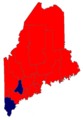
 1948 Maine gubernatorial election results map by county.svg 205 × 322; 22 KB
-
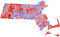 1948 Massachusetts Gubernatorial Election by Town.svg 810 × 502; 182 KB
-
 1948 Michigan gubernatorial election results map by county.svg 287 × 313; 43 KB
-
 1948 Minnesota gubernatorial election results map by county.svg 744 × 744; 352 KB
-
 1948 Missouri gubernatorial election results map by county.svg 284 × 252; 54 KB
-
 1948 Montana gubernatorial election results map by county.svg 316 × 183; 27 KB
-
 1948 Nebraska gubernatorial election results map by county.svg 810 × 379; 32 KB
-
 1948 New Hampshire gubernatorial election results map by county.svg 512 × 1,052; 8 KB
-
 1948 North Carolina gubernatorial election results map by county.svg 426 × 173; 40 KB
-
 1948 North Dakota gubernatorial election results map by county.svg 273 × 163; 18 KB
-
 1948 Ohio gubernatorial election results map by county.svg 810 × 810; 39 KB
-
 1948 Oregon gubernatorial special election results map by county.svg 810 × 608; 33 KB
-
 1948 Rhode Island gubernatorial election results map by county.svg 810 × 810; 13 KB
-

-
 1948 South Dakota gubernatorial election results map by county.svg 243 × 152; 26 KB
-
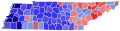 1948 Tennessee gubernatorial election results map by county.svg 810 × 206; 58 KB
-
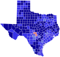 1948 Texas gubernatorial election results map by county.svg 810 × 769; 87 KB
-
 1948 Utah gubernatorial election results map by county.svg 810 × 810; 29 KB
-
 1948 Vermont gubernatorial election results map by county.svg 810 × 810; 17 KB
-
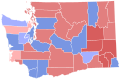 1948 Washington gubernatorial election results map by county.svg 744 × 497; 372 KB
-
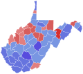 1948 West Virginia gubernatorial election results map by county.svg 810 × 719; 38 KB
-
 1948 Wisconsin gubernatorial election results map by county.svg 810 × 810; 43 KB
-
 1948MaineGubernatorial.png 850 × 1,200; 94 KB
-
 48MaineGovCounties.png 689 × 1,000; 68 KB
-
 Delaware Governor Election Results by County, 1948.svg 810 × 810; 6 KB
-
 Louisiana Governor Election Results by Parish, 1948.svg 810 × 739; 61 KB
-
 Minnesota Governor 1948.png 399 × 426; 6 KB
-
 USgubernatorial1948.png 2,000 × 1,237; 48 KB


