Category:1978 maps of Maine
Jump to navigation
Jump to search
States of the United States: Connecticut · Florida · Georgia · Maine · Maryland · New Jersey · New Mexico · North Carolina · Ohio · Pennsylvania · South Carolina · Texas · West Virginia – Washington, D.C.
| 1975 1977 1978 1979 → |
Media in category "1978 maps of Maine"
The following 7 files are in this category, out of 7 total.
-
 78MaineGovCounties.png 689 × 1,000; 73 KB
-
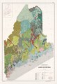
 General soil map Maine LOC 90685328.jpg 5,945 × 8,691; 8.4 MB
-
 General soil map Maine LOC 90685328.tif 5,945 × 8,691; 147.82 MB
-
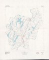
 Kennebec County, Maine LOC 81690041.jpg 7,375 × 8,996; 6.15 MB
-
 Kennebec County, Maine LOC 81690041.tif 7,375 × 8,996; 189.82 MB
-
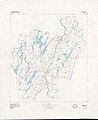
 Water-resources investigations in Maine, 1978 LOC 83692045.jpg 12,054 × 6,595; 9.88 MB
-
 Water-resources investigations in Maine, 1978 LOC 83692045.tif 12,054 × 6,595; 227.44 MB


