Category:19th century topographic maps of Indre
Jump to navigation
Jump to search
Media in category "19th century topographic maps of Indre"
The following 4 files are in this category, out of 4 total.
-
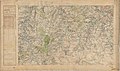
 Carte d'État-major de la France, Feuille Valencay N.E.jpg 23,764 × 13,960; 104.05 MB
-
 Carte d'État-major de la France, Feuille Valencay N.O.jpg 23,764 × 14,037; 104.67 MB
-
 Carte d'État-major de la France, Feuille Valencay S.E.jpg 23,764 × 14,057; 101.08 MB
-
 Carte d'État-major de la France, Feuille Valencay S.O.jpg 23,764 × 14,381; 102.63 MB


