Category:20th-century maps of Greenland
Jump to navigation
Jump to search
Subcategories
This category has the following 8 subcategories, out of 8 total.
- 1900s maps of Greenland (1 F)
Media in category "20th-century maps of Greenland"
The following 12 files are in this category, out of 12 total.
-
 FMIB 36751 Carte de l'Inlandsis Groenlandis.jpeg 775 × 1,691; 364 KB
-
-
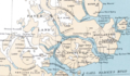 Clavering 1932.tif 1,013 × 591; 1.13 MB
-
 Copepoda (1915) (20672486936).jpg 3,888 × 2,982; 1.91 MB
-
 Crossings of Greenland until 1913.jpg 1,707 × 2,691; 1.89 MB
-
 Crustacea Malacostraca (1916) (20526876449).jpg 3,344 × 2,568; 1.18 MB
-
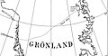 Danish Expedition to Queen Louise Land-1912–1913.jpg 1,440 × 750; 249 KB
-
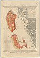
 EB1911 Greenland.jpg 1,109 × 1,818; 1.22 MB
-
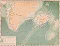
 Karte Nordostgrönland Koch 1911.png 1,196 × 1,542; 1.46 MB
-
 Peary Land map 1903.jpg 1,230 × 932; 446 KB
-
 Roosevelt Range 1903.png 710 × 374; 497 KB
-
 The American Museum journal (c1900-(1918)) (17974342200).jpg 870 × 1,800; 289 KB


_(20672486936).jpg)

_(20526876449).jpg)


)_(17974342200).jpg)