Category:20th-century maps of Oman
Jump to navigation
Jump to search
Countries of Asia: Afghanistan · Armenia‡ · Azerbaijan‡ · Bangladesh · Cambodia · People's Republic of China · Cyprus‡ · Egypt‡ · Georgia‡ · India · Indonesia‡ · Iran · Iraq · Israel · Japan · Jordan · Kazakhstan‡ · Kyrgyzstan · Laos · Lebanon · Malaysia · Mongolia · Myanmar · Nepal · North Korea · Oman · Pakistan · Philippines · Russia‡ · Saudi Arabia · Singapore · South Korea · Sri Lanka · Syria · Tajikistan · Thailand · Turkey‡ · Turkmenistan · United Arab Emirates · Uzbekistan · Vietnam · Yemen
Limited recognition: Abkhazia‡ · Taiwan · State of Palestine
‡: partly located in Asia
Limited recognition: Abkhazia‡ · Taiwan · State of Palestine
‡: partly located in Asia
Media in category "20th-century maps of Oman"
The following 8 files are in this category, out of 8 total.
-
 1967 data of Arabia, Iran and Afghanistan.jpg 3,960 × 2,900; 1.61 MB
-
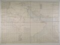
 Admiralty Chart No 3785 Marbat to Masira Island, Published 1930.jpg 16,364 × 11,219; 36.77 MB
-
 D117-Territoire d’Oman.-L2-Ch5.png 1,338 × 1,156; 182 KB
-
 Oman map 1979.gif 1,006 × 1,268; 219 KB
-
 Persian Gulf, Oman and Central Arabia map by F.F. Hunder 1905 (retouched).jpg 7,920 × 5,856; 31.82 MB
-
 Persian Gulf, Oman and Central Arabia map by F.F. Hunder 1905-2.jpg 7,954 × 5,964; 26.92 MB
-
 Persian Gulf, Oman and Central Arabia map by F.F. Hunder 1905.jpg 7,954 × 5,964; 7.17 MB
-
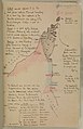 Thomas Bertram map.jpg 773 × 1,199; 202 KB


.jpg)


