Category:27 - 35 Prince Alfred Road
Jump to navigation
Jump to search
| Object location | | View all coordinates using: OpenStreetMap |
|---|
building in Liverpool, Merseyside, UK  | |||||
| Upload media | |||||
| Instance of | |||||
|---|---|---|---|---|---|
| Location | Liverpool, Merseyside, North West England, England | ||||
| Street address |
| ||||
| Heritage designation |
| ||||
 | |||||
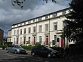
Also known as Hope Terrace, this terrace of five houses dated to the mid-1850s and is Grade II listed.
Media in category "27 - 35 Prince Alfred Road"
The following 4 files are in this category, out of 4 total.
-
 27 - 35 Prince Alfred Road 1.jpg 4,126 × 3,265; 6.51 MB
-
 27 - 35 Prince Alfred Road 2.jpg 4,307 × 3,155; 7.78 MB
-
 Hope Terrace from Wavertree Playground.jpg 3,927 × 2,820; 6.61 MB
-