Category:27 Holmefield Road, Aigburth
Jump to navigation
Jump to search
| Object location | | View all coordinates using: OpenStreetMap |
|---|
building in Liverpool, Merseyside, England, UK  | |||||
| Upload media | |||||
| Instance of | |||||
|---|---|---|---|---|---|
| Location | Liverpool, Merseyside, North West England, England | ||||
| Street address |
| ||||
| Heritage designation |
| ||||
 | |||||
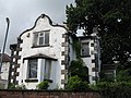
Mid l9th century stucco house, possibly a former hunting lodge, decorated with statues in niches (unidentified) and animals' heads on the gable. Grade II listed.
Media in category "27 Holmefield Road, Aigburth"
The following 7 files are in this category, out of 7 total.
-
 27 Holmefield Road.jpg 2,560 × 1,920; 2.68 MB
-
 Former Hunting Lodge, Holmfield Road - geograph.org.uk - 601474.jpg 640 × 480; 84 KB
-
 Hunting Lodge Detail - geograph.org.uk - 601487.jpg 480 × 640; 73 KB
-
 Side view of 27 Holmefield Road showing niches cu.jpg 1,920 × 2,560; 497 KB
-
 Side view of 27 Holmefield Road showing niches.jpg 2,560 × 1,920; 1.01 MB
-
 Statue at 27 Holmefield Road.jpg 1,920 × 2,560; 1.47 MB
-
 Statues in niches at 27 Holmefield Road.jpg 1,329 × 2,409; 1.69 MB


