Category:2 Waryńskiego Street in Kowary
Jump to navigation
Jump to search
| Object location | | View all coordinates using: OpenStreetMap |
|---|
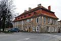
Polski: Kowary, ul. Waryńskiego 2 - dom mieszkalny, dawniej plebania ewangelicka
house in Kowary, Lower Silesian Voivodeship, Poland .JPG) | |||||
| Upload media | |||||
| Instance of | |||||
|---|---|---|---|---|---|
| Location | Kowary, Karkonosze County, Lower Silesian Voivodeship, Poland | ||||
| Street address |
| ||||
| Heritage designation |
| ||||
| Inception |
| ||||
 | |||||
Media in category "2 Waryńskiego Street in Kowary"
The following 5 files are in this category, out of 5 total.
-
 Dom przy ul. Waryńskiego 2 w Kowarach.jpg 4,688 × 3,151; 9.39 MB
-
 Kowary, Pastorówka - fotopolska.eu (262887).jpg 1,200 × 800; 215 KB
-
 Kowary, Pastorówka - fotopolska.eu (262912).jpg 1,400 × 942; 307 KB
-
 Kowary-Schule-3.jpg 2,558 × 1,705; 1.64 MB
-
 PL Kowary, ul. Waryńskiego 2 (0172-001).JPG 3,202 × 2,133; 3.06 MB

.jpg)
.jpg)
