Category:4 Waryńskiego Street in Białystok
Jump to navigation
Jump to search
| Object location | | View all coordinates using: OpenStreetMap |
|---|
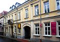
Polski: Białystok, ul. Waryńskiego 4 - kamienica, koniec XIX w.
Media in category "4 Waryńskiego Street in Białystok"
The following 6 files are in this category, out of 6 total.
-
 Białystok, kamienica, ul. Waryńskiego 4, k. XIX w., 01.JPG 2,134 × 2,848; 1 MB
-
 Białystok, kamienica, ul. Waryńskiego 4, k. XIX w., 02.JPG 2,848 × 2,134; 1.15 MB
-
 Białystok, kamienica, ul. Waryńskiego 4, k. XIX w., 03.JPG 2,848 × 2,134; 1.16 MB
-
 Białystok, kamienica, ul. Waryńskiego 4, k. XIX w., 04.JPG 2,848 × 2,134; 1.19 MB
-
 Kamienica na ul. Waryńskiego 4 w Białymstoku.JPG 3,872 × 2,592; 4.58 MB
-
 Kamienica Warynskiego 4 Białystok.JPG 4,275 × 2,995; 7.25 MB


