Category:A16 road (England)
Jump to navigation
Jump to search
road in East Midlands region of England  | |||||
| Upload media | |||||
| Instance of | |||||
|---|---|---|---|---|---|
| Location |
| ||||
| Transport network |
| ||||
| Length |
| ||||
| Different from | |||||
 | |||||
Media in category "A16 road (England)"
The following 16 files are in this category, out of 16 total.
-
 A16 Approaching Walmsgate - geograph.org.uk - 657541.jpg 640 × 480; 87 KB
-
 A16 at Scotland Farm - geograph.org.uk - 483259.jpg 640 × 482; 75 KB
-
 A16 at Walmsgate - geograph.org.uk - 657517.jpg 640 × 480; 70 KB
-
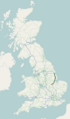 A16 road map.png 250 × 425; 48 KB
-
 A16 Roundabout from A157 - geograph.org.uk - 535316.jpg 640 × 480; 73 KB
-
 A16 towards Burwell - geograph.org.uk - 3221532.jpg 3,088 × 2,056; 2.64 MB
-
 A16 underpass - geograph.org.uk - 1051850.jpg 640 × 427; 74 KB
-
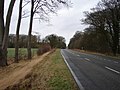
 A16, Utterby - geograph.org.uk - 382802.jpg 640 × 480; 71 KB
-
 Former Unitarian Chapel - geograph.org.uk - 336157.jpg 427 × 640; 53 KB
-
 Dowdyke Road - geograph.org.uk - 416382.jpg 640 × 489; 68 KB
-
 Kirton, Lincolnshire geograph-3728354-by-Ben-Brooksbank.jpg 2,342 × 1,350; 2.42 MB
-
 Lane end - geograph.org.uk - 415878.jpg 640 × 417; 58 KB
-
 UK road A16.PNG 568 × 184; 6 KB
-
 UK road A16.svg 345 × 191; 4 KB
-
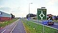
 Choice of Route - geograph.org.uk - 416361.jpg 640 × 427; 76 KB
-
 The A16 Boston to Grimsby Road - geograph.org.uk - 443727.jpg 640 × 480; 82 KB


