Category:Abama Golf
Jump to navigation
Jump to search
| Object location | | View all coordinates using: OpenStreetMap |
|---|
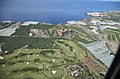
English: Pictures of Abama Golf near the village Playa San Juan belongs to the municipality Guía de Isora on Tenerife one of the islands of the Canary Islands in Spain
 | |||||
| Upload media | |||||
| Instance of | |||||
|---|---|---|---|---|---|
| Location | Tenerife, Atlantic Ocean, international waters | ||||
 | |||||
Media in category "Abama Golf"
The following 6 files are in this category, out of 6 total.
-
 A0186 Tenerife, hotel Abama aerial view.jpg 7,051 × 4,705; 13.53 MB
-
 A0188 Tenerife, hotel Abama aerial view.jpg 7,526 × 4,974; 15.18 MB
-
 A0363 Tenerife, hotel Abama aerial view.jpg 6,096 × 4,068; 12.78 MB
-
 A0366 Tenerife, hotel Abama aerial view.jpg 6,606 × 4,254; 12.59 MB
-
 A0368 Tenerife, hotel Abama aerial view.jpg 6,589 × 4,253; 9.94 MB
-
 Teneriffa - Piedra Hincada - Abama Golf ^ Spa Resort - panoramio.jpg 4,320 × 3,240; 3.36 MB


