Category:Abri Unterkobel
Jump to navigation
Jump to search
| Object location | | View all coordinates using: OpenStreetMap |
|---|
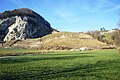
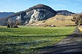
Deutsch: Der Abri Unterkobel ist eine archäologische Fundstelle in einer Felswand unterhalb Kobelwald auf dem Gebiet der politischen Gemeinde Oberriet im Kanton St. Gallen in der Schweiz.
archaeological site in the village of Oberriet  | |||||
| Upload media | |||||
| Instance of | |||||
|---|---|---|---|---|---|
| Location | Oberriet, Rheintal Constituency, canton St. Gallen, Switzerland | ||||
| Time of discovery or invention |
| ||||
 | |||||
Media in category "Abri Unterkobel"
The following 8 files are in this category, out of 8 total.
-
 Abri Unterkobel G.JPG 4,592 × 3,056; 6.85 MB
-
 Abri Unterkobel Hn.JPG 3,056 × 4,592; 6.81 MB
-
 Abri Unterkobel Hz.JPG 3,056 × 4,592; 7.47 MB
-
 Abri Unterkobel Q z.JPG 4,592 × 3,056; 7.03 MB
-
 Abri Unterkobel Z.JPG 2,563 × 2,518; 3.7 MB
-
 Deponie Unterkobel 2013 n.JPG 4,592 × 3,056; 6.19 MB
-
 Deponie Unterkobel 2013 w.JPG 4,592 × 3,056; 6.87 MB
-
 Unterkobel 2013.JPG 4,592 × 3,056; 6.24 MB


