Category:Achterom 2, Harderwijk
Jump to navigation
Jump to search
| Object location | | View all coordinates using: OpenStreetMap |
|---|
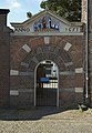
building in Harderwijk, Netherlands  | |||||
| Upload media | |||||
| Instance of | |||||
|---|---|---|---|---|---|
| Location | Harderwijk, Gelderland, Netherlands | ||||
| Street address |
| ||||
| Located on street |
| ||||
| Heritage designation |
| ||||
 | |||||
|
This is a category about rijksmonument number 20155
|
| Address |
|
Media in category "Achterom 2, Harderwijk"
The following 7 files are in this category, out of 7 total.
-
 20180722 165 harderwijk.jpg 4,000 × 6,000; 9.7 MB
-
 20180722 166 harderwijk.jpg 6,000 × 4,000; 9.79 MB
-
 Achterom 2 - Harderwijk.jpg 2,736 × 3,648; 4.64 MB
-
 Achterom 2, aanzicht - Harderwijk - 20100960 - RCE.jpg 1,200 × 808; 183 KB
-
 Achterom 2, achtergevel - Harderwijk - 20100961 - RCE.jpg 1,200 × 804; 228 KB
-
 Harderwijk poortje A.jpg 1,767 × 2,554; 793 KB
-
 Poortje bij Achterom 2, Harderwijk, Netherlands - panoramio (29).jpg 2,048 × 1,148; 493 KB


.jpg)