Category:Adlestrop
Jump to navigation
Jump to search
village in Gloucestershire, England, UK  | |||||
| Upload media | |||||
| Instance of | |||||
|---|---|---|---|---|---|
| Location | Cotswold, Gloucestershire, South West England, England | ||||
| Population |
| ||||
 | |||||
English: Adlestrop (formerly Titlestrop or Edestrop) is a village and civil parish in the English county of Gloucestershire. It is known as Tedestrop in the Domesday Book.
Français : Adlestrop est un village anglais situé dans le district de Cotswold et le comté du Gloucestershire.
Subcategories
This category has the following 5 subcategories, out of 5 total.
A
- Adlestrop House (5 F)
D
Media in category "Adlestrop"
The following 200 files are in this category, out of 203 total.
(previous page) (next page)-
 'Through the Churchyard Gate' - geograph.org.uk - 228044.jpg 640 × 423; 106 KB
-
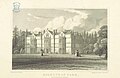 Neale(1818) p2.016 - Adlestrop Park, Gloucestershire.jpg 1,872 × 1,215; 577 KB
-
 A danger removed - geograph.org.uk - 3410794.jpg 640 × 480; 129 KB
-
 A little lavender - geograph.org.uk - 1951506.jpg 4,000 × 3,000; 4.09 MB
-
 A track into The Dell - geograph.org.uk - 1951499.jpg 4,000 × 3,000; 3.4 MB
-
 A436 at Cornwell Holt - geograph.org.uk - 4672912.jpg 1,920 × 1,243; 672 KB
-
 A436 between Adlestrop and Chastleton - geograph.org.uk - 181343.jpg 640 × 461; 118 KB
-
 A436 east of Adlestrop - geograph.org.uk - 4101471.jpg 1,600 × 1,064; 704 KB
-
 A436 passes through the Black Plantation - geograph.org.uk - 3991520.jpg 3,648 × 2,736; 2.42 MB
-
 A436 south of Adlestrop Park - geograph.org.uk - 3991517.jpg 3,648 × 2,736; 2.42 MB
-
 A436, late autumn - geograph.org.uk - 2721255.jpg 1,024 × 768; 619 KB
-
 Access to Chastleton Barrow - geograph.org.uk - 4101533.jpg 1,600 × 1,064; 407 KB
-
 Adlestrop - geograph.org.uk - 102313.jpg 640 × 429; 91 KB
-
 Adlestrop Church - geograph.org.uk - 6192834.jpg 1,600 × 1,200; 743 KB
-
 Adlestrop cottages - geograph.org.uk - 2485972.jpg 4,288 × 3,216; 3.76 MB
-
 Adlestrop Cottages - geograph.org.uk - 6192838.jpg 1,600 × 1,200; 453 KB
-
 Adlestrop in August - geograph.org.uk - 3640497.jpg 1,200 × 900; 1.48 MB
-
 Adlestrop Park - geograph.org.uk - 901016.jpg 640 × 426; 88 KB
-
 Adlestrop Park - geograph.org.uk - 901393.jpg 640 × 426; 92 KB
-
 Adlestrop Park, Adlestrop - geograph.org.uk - 3376875.jpg 640 × 381; 175 KB
-
 Adlestrop post office - geograph.org.uk - 2485974.jpg 4,288 × 3,216; 1.36 MB
-
 Adlestrop Post Office - geograph.org.uk - 3641810.jpg 1,200 × 849; 1.18 MB
-
 Adlestrop sign - detail - geograph.org.uk - 3109831.jpg 640 × 480; 79 KB
-
 Adlestrop village - geograph.org.uk - 2499726.jpg 4,288 × 3,216; 2.95 MB
-
 Adlestrop village hall - geograph.org.uk - 2499728.jpg 4,288 × 3,216; 1.58 MB
-
 Adlestrop Village Hall - geograph.org.uk - 920911.jpg 640 × 426; 71 KB
-
 Adlestrop village sign and bus shelter - geograph.org.uk - 290719.jpg 640 × 427; 114 KB
-
 Adlestrop's famous bus shelter dedicated to Edward Thomas - geograph.org.uk - 3907443.jpg 4,752 × 3,168; 4.62 MB
-
 Adlestrop, churchyard gate - geograph.org.uk - 3640512.jpg 760 × 1,024; 934 KB
-
 Adlestrop, Cotswolds (48611017578).jpg 1,024 × 768; 190 KB
-
 Adlestrop, Cotswolds (48611017708).jpg 1,024 × 768; 392 KB
-
 Adlestrop, Cotswolds (48611018443).jpg 768 × 1,024; 343 KB
-
 Adlestrop, Cotswolds (48611018678).jpg 1,024 × 768; 287 KB
-
 Adlestrop, Cotswolds (48611019303).jpg 1,287 × 611; 216 KB
-
 Adlestrop, Cotswolds (48611375466).jpg 768 × 1,024; 480 KB
-
 Adlestrop, Cotswolds (48611375956).jpg 1,024 × 768; 389 KB
-
 Adlestrop, Cotswolds (48611376121).jpg 1,024 × 768; 386 KB
-
 Adlestrop, Cotswolds (48611376516).jpg 1,024 × 768; 260 KB
-
 Adlestrop, Cotswolds (48611376666).jpg 1,024 × 768; 355 KB
-
 Adlestrop, Cotswolds (48611530092).jpg 768 × 1,024; 382 KB
-
 Adlestrop, Cotswolds (48611530767).jpg 1,024 × 768; 329 KB
-
 Adlestrop, Cotswolds (48611530837).jpg 1,024 × 768; 332 KB
-
 Adlestrop, Cotswolds (48611531022).jpg 768 × 1,024; 311 KB
-
 Adlestrop, Cotswolds (48611531112).jpg 1,123 × 700; 260 KB
-
 Adlestrop, Cotswolds (48611531222).jpg 1,258 × 625; 186 KB
-
 Adlestrop, Main Street - geograph.org.uk - 3641798.jpg 1,200 × 871; 1.28 MB
-

-
 Adlestrop, Schoolers Lane - geograph.org.uk - 3641782.jpg 1,024 × 768; 1.01 MB
-
 Adlestrop, view from Schoolers Lane - geograph.org.uk - 3641775.jpg 1,024 × 768; 908 KB
-
 Alongside Long Drive - geograph.org.uk - 6609454.jpg 1,024 × 768; 330 KB
-
 Approaching Adlestrop Church - geograph.org.uk - 3641822.jpg 899 × 1,024; 1.13 MB
-
 Approaching Chastleton - geograph.org.uk - 3108446.jpg 640 × 480; 125 KB
-
 Ascend the hill - geograph.org.uk - 2498278.jpg 4,288 × 3,216; 3.05 MB
-
 Avenue approaching Chastleton - geograph.org.uk - 451055.jpg 640 × 477; 145 KB
-
 Barns at Daylesford New Farm - geograph.org.uk - 4174143.jpg 1,024 × 768; 179 KB
-
 Beech lane in early October - geograph.org.uk - 989838.jpg 640 × 480; 174 KB
-
 Berries (6313699102).jpg 2,896 × 1,944; 2.47 MB
-
 Black Plantation - geograph.org.uk - 989841.jpg 480 × 640; 186 KB
-
 Bridge over the railway near Daylesford - geograph.org.uk - 5603726.jpg 6,000 × 4,000; 4.73 MB
-
 Change sides - geograph.org.uk - 2499723.jpg 4,288 × 3,216; 1.28 MB
-
 Chastleton, Adlestron Hill - geograph.org.uk - 5461214.jpg 5,520 × 3,680; 5.23 MB
-
 Coachmans Cottage and school house - geograph.org.uk - 2485977.jpg 4,288 × 3,216; 2.38 MB
-
 Cottages in Adlestrop - geograph.org.uk - 3960345.jpg 800 × 571; 106 KB
-
 Country junction - geograph.org.uk - 2494507.jpg 4,288 × 3,216; 3.22 MB
-
 Country junction - geograph.org.uk - 2494510.jpg 4,288 × 3,216; 1.22 MB
-
 Cow parsley in a field headland - geograph.org.uk - 5425061.jpg 1,024 × 768; 333 KB
-
 Cricket field, Adlestrop Park - geograph.org.uk - 901024.jpg 640 × 426; 87 KB
-
 Crossroads near Adlestrop - geograph.org.uk - 2255194.jpg 640 × 480; 97 KB
-
 Daylesford - geograph.org.uk - 6426716.jpg 1,200 × 803; 1.27 MB
-
 Daylesford church - geograph.org.uk - 5863094.jpg 680 × 1,024; 279 KB
-
 Daylesford Church - geograph.org.uk - 6574698.jpg 921 × 1,024; 307 KB
-
 Daylesford Hill Farm - geograph.org.uk - 5863155.jpg 1,024 × 680; 241 KB
-
 Daylesford Park - geograph.org.uk - 6192842.jpg 1,600 × 1,200; 666 KB
-

-
 Down the valley - geograph.org.uk - 2499715.jpg 4,288 × 3,216; 3.3 MB
-
 Drive in Daylesford Park - geograph.org.uk - 5863151.jpg 1,024 × 680; 292 KB
-
 Entrance to Daylesford Park - geograph.org.uk - 5863166.jpg 1,024 × 680; 299 KB
-
 Evenlode Grounds Farm (1) - geograph.org.uk - 2498207.jpg 4,288 × 3,216; 1.37 MB
-
 Farm accommodation - geograph.org.uk - 1951454.jpg 4,000 × 3,000; 3.57 MB
-
 Farmhouse driveway - geograph.org.uk - 1951481.jpg 4,000 × 3,000; 2.72 MB
-
 Field of cattle at Daylesford - geograph.org.uk - 5603729.jpg 6,000 × 4,000; 7.36 MB
-
 Fishing Lake - geograph.org.uk - 1571250.jpg 640 × 480; 87 KB
-
 Footpath leaves road - geograph.org.uk - 2499725.jpg 4,288 × 3,216; 2.75 MB
-
 Footpath to Chastleton - geograph.org.uk - 2499724.jpg 4,288 × 3,216; 4.81 MB
-
 Footpath to Daylesford - geograph.org.uk - 1951463.jpg 4,000 × 3,000; 4.1 MB
-
 Forest at the A436 - geograph.org.uk - 3925717.jpg 1,600 × 1,200; 443 KB
-
 Four ways to go (1) - geograph.org.uk - 2498326.jpg 4,288 × 3,216; 2.65 MB
-
 Four ways to go (2) - geograph.org.uk - 2499709.jpg 4,288 × 3,216; 4.95 MB
-
 Four ways to go (3) - geograph.org.uk - 2499710.jpg 4,288 × 3,216; 2.75 MB
-
 Four ways to go (4) - geograph.org.uk - 2499711.jpg 4,288 × 3,216; 1.63 MB
-

-
 Gloucestershire countryside - geograph.org.uk - 2494513.jpg 4,288 × 3,216; 2.34 MB
-
 Gulls and crows feeding on harrowed field - geograph.org.uk - 6606612.jpg 1,024 × 768; 262 KB
-
 Heading towards London - geograph.org.uk - 1572727.jpg 640 × 480; 95 KB
-
 Hill Barn (1) - geograph.org.uk - 2499718.jpg 4,288 × 3,216; 1.07 MB
-
 Hill Barn (2) - geograph.org.uk - 2499719.jpg 4,288 × 3,216; 1.41 MB
-
 Hillside Farm (1) - geograph.org.uk - 2494511.jpg 4,288 × 3,216; 2.26 MB
-
 Hillside Farm (2) - geograph.org.uk - 2498206.jpg 4,288 × 3,216; 1.6 MB
-
 Hillside spring - geograph.org.uk - 2498287.jpg 4,288 × 3,216; 4.84 MB
-

-
 Horseriding on Country lane, Daylesford - geograph.org.uk - 6606615.jpg 1,024 × 768; 312 KB
-
 Inset telephone box - geograph.org.uk - 2485973.jpg 3,216 × 4,288; 2.35 MB
-
 Junction with road to Stow on Wold - geograph.org.uk - 6393775.jpg 800 × 450; 71 KB
-
 Lake in the park (1) - geograph.org.uk - 2494496.jpg 4,288 × 3,216; 5.83 MB
-
 Lake in the park (2) - geograph.org.uk - 2494502.jpg 4,288 × 3,216; 2.88 MB
-
 Lane out of Adlestrop - geograph.org.uk - 4101432.jpg 1,600 × 1,064; 413 KB
-
 Lane to Adlestrop and Evenlode - geograph.org.uk - 1450039.jpg 640 × 480; 222 KB
-
 Life and death - geograph.org.uk - 2497208.jpg 3,216 × 4,288; 1.46 MB
-
 Long Drive - geograph.org.uk - 6609458.jpg 768 × 1,024; 268 KB
-
 Lower Lake - geograph.org.uk - 6393782.jpg 800 × 450; 123 KB
-
 Lych gate to Daylesford church - geograph.org.uk - 5863099.jpg 1,024 × 680; 343 KB
-
 Main line tracks - geograph.org.uk - 2494508.jpg 4,288 × 3,216; 1.46 MB
-
 Memorial to Warren Hastings - geograph.org.uk - 5863107.jpg 680 × 1,024; 227 KB
-
 Minor road to Cornwell - geograph.org.uk - 3742740.jpg 1,500 × 999; 357 KB
-
 Minor road to the A436 - geograph.org.uk - 3742737.jpg 1,500 × 999; 308 KB
-
 Muddy way - geograph.org.uk - 2494494.jpg 4,288 × 3,216; 3.58 MB
-
 North entrance to Daylesford Estate - geograph.org.uk - 6606657.jpg 1,024 × 768; 330 KB
-
 Ordnance Survey Cut Mark - geograph.org.uk - 4548841.jpg 480 × 640; 131 KB
-
 Ordnance Survey One-Inch Sheet 93 Stow on the Wold, Published 1919.jpg 11,894 × 8,926; 10.48 MB
-
 Over the bridge - geograph.org.uk - 1571265.jpg 640 × 480; 117 KB
-
 Over the brook - geograph.org.uk - 1571238.jpg 640 × 480; 114 KB
-
 Over the crest - geograph.org.uk - 2499713.jpg 4,288 × 3,216; 3.02 MB
-
 Over the railway - geograph.org.uk - 1951460.jpg 3,000 × 4,000; 2.72 MB
-
 Over the river - geograph.org.uk - 1571308.jpg 640 × 480; 80 KB
-
 Park Lodge - geograph.org.uk - 2494499.jpg 4,288 × 3,216; 1.36 MB
-
 Part of the Daylesford Estate - geograph.org.uk - 6606661.jpg 1,024 × 768; 279 KB
-
 Path and field on Kingham Hill - geograph.org.uk - 5587103.jpg 6,000 × 4,000; 5.38 MB
-
 Path between A436 and Chastleton Barrow - geograph.org.uk - 3410788.jpg 640 × 480; 101 KB
-
 Path meets road - geograph.org.uk - 1951473.jpg 4,000 × 3,000; 4.2 MB
-
 Path meets road - geograph.org.uk - 2494504.jpg 4,288 × 3,216; 3.24 MB
-

-
 Path to Adlestrop - geograph.org.uk - 6393747.jpg 800 × 450; 161 KB
-
 Path to Peasewell Wood - geograph.org.uk - 6393755.jpg 800 × 450; 85 KB
-
 Path to Peasewell Wood - geograph.org.uk - 6393758.jpg 800 × 450; 93 KB
-
 Pitch in the park (1) - geograph.org.uk - 2494497.jpg 4,288 × 3,216; 1.8 MB
-
 Pitch in the park (2) - geograph.org.uk - 2494498.jpg 4,288 × 3,216; 1.07 MB
-

-

-
 Public footpath and driveway, Daylesford Estate - geograph.org.uk - 6606671.jpg 707 × 1,024; 293 KB
-

-
 Puddly lane near Whitequarry Hill - geograph.org.uk - 5587057.jpg 6,000 × 4,000; 5.66 MB
-
 Railway at Daylesford - geograph.org.uk - 6426711.jpg 1,200 × 812; 1.24 MB
-

-
 Road to Cornwell - geograph.org.uk - 5425052.jpg 600 × 800; 179 KB
-
 Road to Norton Gap - geograph.org.uk - 989834.jpg 640 × 480; 169 KB
-
 Seven Shires Way - geograph.org.uk - 2682212.jpg 640 × 480; 53 KB
-
 Seven Shires Way - geograph.org.uk - 2682239.jpg 640 × 480; 95 KB
-
 Seven Shires Way - geograph.org.uk - 2682245.jpg 640 × 480; 52 KB
-
 Signpost on the A436 - geograph.org.uk - 5425050.jpg 768 × 1,024; 346 KB
-
 Soggy field near Cornwell - geograph.org.uk - 5587032.jpg 6,000 × 4,000; 6.08 MB
-
 Start of bridleway - geograph.org.uk - 2485978.jpg 4,288 × 3,216; 2.47 MB
-
 Start of the footpath - geograph.org.uk - 1571234.jpg 640 × 480; 94 KB
-
 Stile at Adlestrop - geograph.org.uk - 920932.jpg 640 × 426; 96 KB
-
 Stop the Show (6300803760).jpg 2,500 × 1,803; 1.9 MB
-
 Telephone box, Adlestrop - geograph.org.uk - 920908.jpg 426 × 640; 83 KB
-
 The A436 east of Adlestrop - geograph.org.uk - 2302483.jpg 1,024 × 768; 350 KB
-
 The after lunch cud chew - geograph.org.uk - 2499720.jpg 4,288 × 3,216; 3.13 MB
-
 The memorial to Warren Hastings - geograph.org.uk - 5863106.jpg 680 × 1,024; 311 KB
-
 The Old Schoolhouse, Daylesford (geograph 7311868).jpg 1,024 × 705; 215 KB
-
 The ways unite - geograph.org.uk - 2498298.jpg 4,288 × 3,216; 3.74 MB
-
 Three ways to go (1) - geograph.org.uk - 2498304.jpg 4,288 × 3,216; 3.29 MB
-
 Three ways to go (2) - geograph.org.uk - 2498309.jpg 4,288 × 3,216; 2.98 MB
-
 Three ways to go (3) - geograph.org.uk - 2498311.jpg 4,288 × 3,216; 2.66 MB
-
 Through the gate - geograph.org.uk - 2498294.jpg 4,288 × 3,216; 2.94 MB
-

-
 Towards Stow - geograph.org.uk - 3640482.jpg 1,200 × 900; 1.3 MB
-
 Towards the railway - geograph.org.uk - 1951457.jpg 4,000 × 3,000; 3.26 MB
-
 Towards the road - geograph.org.uk - 2494503.jpg 4,288 × 3,216; 3.93 MB
-
 Track on Daylesford Park - geograph.org.uk - 5863145.jpg 1,024 × 680; 320 KB
-
 Two ways to go (1) - geograph.org.uk - 2499721.jpg 4,288 × 3,216; 1.56 MB
-
 Two ways to go (2) - geograph.org.uk - 2499722.jpg 4,288 × 3,216; 1.71 MB
-
 Two ways to go - geograph.org.uk - 1952252.jpg 4,000 × 3,000; 3.64 MB
-
 Up hill to Fern Farm - geograph.org.uk - 3640487.jpg 1,200 × 888; 1.45 MB
-
 View from St. Peter's churchyard 1 - geograph.org.uk - 1440830.jpg 480 × 640; 252 KB
-
 View from St. Peter's churchyard 2 - geograph.org.uk - 1440835.jpg 480 × 640; 286 KB
-
 View from St. Peter's churchyard 3 - geograph.org.uk - 1440840.jpg 640 × 480; 248 KB
-
 View from the railway bridge - geograph.org.uk - 1572721.jpg 640 × 480; 79 KB
-
 Village store in Adlestrop - geograph.org.uk - 901440.jpg 640 × 426; 77 KB
-
 Adlestrop cricket pitch - geograph.org.uk - 451123.jpg 640 × 477; 88 KB
-
 Adlestrop lake - geograph.org.uk - 451121.jpg 640 × 477; 131 KB
-
 Arable land near Adlestrop 1 - geograph.org.uk - 1450042.jpg 640 × 480; 221 KB
-
 Arable land near Adlestrop 2 - geograph.org.uk - 1450044.jpg 640 × 480; 242 KB
-
 Barn near Icomb - geograph.org.uk - 280060.jpg 640 × 427; 104 KB
-
 BCL 87-20 - geograph.org.uk - 322503.jpg 480 × 640; 137 KB
-
 Beech lane in Autumn. - geograph.org.uk - 280066.jpg 427 × 640; 129 KB
-
 Cottages opposite Adlestrop church - geograph.org.uk - 451116.jpg 640 × 477; 124 KB
-
 Drive to Bledington Grounds Farm - geograph.org.uk - 322527.jpg 640 × 480; 84 KB
-
 Footpath beside Bledington Heath - geograph.org.uk - 322521.jpg 640 × 480; 151 KB
-
 Footpath into Adlestrop Park - geograph.org.uk - 451129.jpg 640 × 477; 89 KB
-
 Former railway line - geograph.org.uk - 322528.jpg 640 × 480; 136 KB
-

-
 Gateway to Adlestrop - geograph.org.uk - 181341.jpg 640 × 480; 128 KB
-
 Jay Barn - geograph.org.uk - 280063.jpg 640 × 427; 72 KB
-
 Lane through the trees - geograph.org.uk - 234045.jpg 640 × 480; 120 KB
-
 Looking North - geograph.org.uk - 322524.jpg 640 × 480; 89 KB
-
 Macmillan Way south of Chastleton - geograph.org.uk - 451066.jpg 640 × 477; 93 KB
-
 Peasewell Wood - geograph.org.uk - 314013.jpg 640 × 480; 97 KB
-
 Road junction - geograph.org.uk - 234043.jpg 640 × 480; 84 KB
-
 Sunlit hedge - geograph.org.uk - 322519.jpg 480 × 640; 150 KB
-
 Through the Green Plantation - geograph.org.uk - 234044.jpg 640 × 480; 120 KB

_p2.016_-_Adlestrop_Park,_Gloucestershire.jpg)


.jpg)
.jpg)
.jpg)
.jpg)
.jpg)
.jpg)
.jpg)
.jpg)
.jpg)
.jpg)
.jpg)
.jpg)
.jpg)
.jpg)
.jpg)
.jpg)


.jpg)


_-_geograph.org.uk_-_2498207.jpg)


_-_geograph.org.uk_-_2498326.jpg)
_-_geograph.org.uk_-_2499709.jpg)
_-_geograph.org.uk_-_2499710.jpg)
_-_geograph.org.uk_-_2499711.jpg)


_-_geograph.org.uk_-_2499718.jpg)
_-_geograph.org.uk_-_2499719.jpg)
_-_geograph.org.uk_-_2494511.jpg)
_-_geograph.org.uk_-_2498206.jpg)


_-_geograph.org.uk_-_2494496.jpg)
_-_geograph.org.uk_-_2494502.jpg)


_-_geograph.org.uk_-_2494497.jpg)
_-_geograph.org.uk_-_2494498.jpg)


.jpg)


.jpg)

_-_geograph.org.uk_-_2498304.jpg)
_-_geograph.org.uk_-_2498309.jpg)
_-_geograph.org.uk_-_2498311.jpg)


_-_geograph.org.uk_-_2499721.jpg)
_-_geograph.org.uk_-_2499722.jpg)


