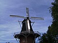
Category:Aeolus, Oldehove
Jump to navigation
Jump to search
| Object location | | View all coordinates using: OpenStreetMap |
|---|
mill in Oldehove, the Netherlands _NL_(ldr).jpg) | |||||
| Upload media | |||||
| Instance of | |||||
|---|---|---|---|---|---|
| Location | Oldehove, Groningen, Netherlands | ||||
| Street address |
| ||||
| Located on street |
| ||||
| Has use | |||||
| Heritage designation |
| ||||
| Source of energy | |||||
 | |||||
|
This is a category about rijksmonument number 31397
|
| Address |
|
Media in category "Aeolus, Oldehove"
The following 15 files are in this category, out of 15 total.
-
 20080801 Aeolus Oldehove (Gn) NL (detail) 1.jpg 1,741 × 1,874; 480 KB
-
 20080801 Aeolus Oldehove (Gn) NL (detail) 2.jpg 2,592 × 1,944; 439 KB
-
 20080801 Aeolus Oldehove (Gn) NL (ldr).jpg 2,143 × 3,000; 3.67 MB
-
 Achtkante stellingmolen van voren gefotografeerd - Oldehove - 20365650 - RCE.jpg 1,195 × 1,200; 213 KB
-
 Achtkante stellingmolen van voren gefotografeerd - Oldehove - 20368192 - RCE.jpg 1,198 × 1,200; 229 KB
-
 Dorpsgezicht met op de achtergrond twee stellingmolens - Oldehove - 20364428 - RCE.jpg 1,200 × 1,200; 200 KB
-
 Molen Aeolus uit 1846.JPG 3,456 × 4,608; 1.68 MB
-
 Oldehove, korenmolen Aeolus RM31397 foto7 2013-08-04 15.23.jpg 3,312 × 4,416; 10.81 MB
-
 Oldehove, molen foto2 2008-07-05 16.33.JPG 3,072 × 2,304; 1.81 MB
-

-

-

-

-

-

_NL_(detail)_1.jpg)
_NL_(detail)_2.jpg)


