Category:Aerial photographs of Wiesbaden
Jump to navigation
Jump to search
Districts of Hesse:
Bergstraße · Darmstadt-Dieburg · Fulda · Gießen · Groß-Gerau · Hersfeld-Rotenburg · Hochtaunus · Kassel · Lahn-Dill · Limburg-Weilburg · Main-Kinzig · Main-Taunus · Marburg-Biedenkopf · Odenwald · Offenbach · Rheingau-Taunus · Schwalm-Eder · Vogelsberg · Waldeck-Frankenberg · Werra-Meißner · Wetterau
Urban districts (cities):
Subcategories
This category has only the following subcategory.
Media in category "Aerial photographs of Wiesbaden"
The following 57 files are in this category, out of 57 total.
-
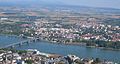
 20150714 Wiesbaden-Mainz Rheinufer IMG 6260 by sebaso.jpg 5,184 × 3,456; 7.95 MB
-
 Aerial, Wiesbaden (P1090538).jpg 3,456 × 4,608; 13.27 MB
-
 Aerial, Wiesbaden (P1090539).jpg 4,597 × 3,448; 8.42 MB
-
 Bka-wiesbaden-w1.jpg 1,360 × 1,024; 1,001 KB
-
 Chemiepark Kalle-Albert, Wiesbaden (P1090528).jpg 4,359 × 3,269; 8.35 MB
-
 Chemische Fabrik Kalle fg01.JPG 1,000 × 665; 705 KB
-
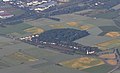
 Erbenheim-airbase1.jpg 3,888 × 2,592; 4.07 MB
-
 Erbenheim-airbase2.jpg 3,888 × 2,592; 10.34 MB
-
 Flugplatz Wiesbaden-Erbenheim 91.jpg 4,288 × 2,848; 4.62 MB
-
 Fort Biehler Mainz-Kastel.jpg 936 × 570; 216 KB
-
 Hessisches Landesamt fuer Bodenmanagement und Geoinformation.jpg 2,113 × 1,584; 1.36 MB
-
 ISS018-E-26441 - View of Earth.jpg 3,072 × 2,040; 446 KB
-
 ISS052-E-8312 - View of Germany.jpg 4,928 × 3,280; 2.61 MB
-
 ISS052-E-8320 - View of Germany.jpg 4,928 × 3,280; 2.76 MB
-
 Luftbild Hesslerhof.jpg 971 × 806; 339 KB
-

-
 Luftbild Mainz-Kastel Theodor-Heuss-Brücke 2008 Wolfgang Pehlemann.jpg 800 × 425; 105 KB
-
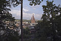
 Luftbild Neroberg Opelbad russisch-orthodoxe Kirche 2008.jpg 800 × 475; 107 KB
-
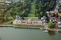
 Luftbild Schiersteiner Hafen.jpg 2,568 × 1,382; 2.34 MB
-

-
 Luftbild Wiesbaden Hessisches Staatstheater IMG 0130.jpg 800 × 550; 139 KB
-

-

-
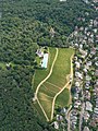
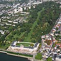 Luftbild Wiesbaden Schlosspark mit Schloss Biebrich.jpg 800 × 800; 500 KB
-
 Luftbild Wiesbaden-Biebrich 2008.jpg 800 × 600; 189 KB
-
 Luftbild Wiesbaden-Schierstein.jpg 1,600 × 900; 1.25 MB
-
 Mainspitze fg01.JPG 1,000 × 665; 627 KB
-
 Mainz aerial photograph crop nebeljungenstreich.png 519 × 391; 358 KB
-
 Mainz aerial photograph.jpg 2,000 × 1,000; 1.76 MB
-
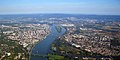
 Mainz Wiesbaden aerial.jpg 5,744 × 4,000; 10.69 MB
-
 Mainz, Wiesbaden 2011-07-19 (cropped, Hesslerhof).jpg 1,104 × 452; 129 KB
-
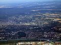
 Mainz, Wiesbaden 2011-07-19.jpg 3,488 × 2,616; 2.13 MB
-
 MKa 0065 Opelbad.jpg 2,550 × 1,910; 3.6 MB
-
 MKa 0066 Opelbad.jpg 3,461 × 2,596; 7.9 MB
-
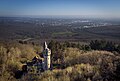
 Neroberg, Wiesbaden (P1090531).jpg 3,002 × 2,252; 4.96 MB
-
 Opelbad, Wiesbaden (P1090536).jpg 3,456 × 4,608; 11.79 MB
-
 Polizeipraesidium-Westhessen.jpg 500 × 315; 120 KB
-
 Roemertor-Alter Friedhof-220511.jpg 1,200 × 800; 525 KB
-
 Russian-orthodox-church-wiesbaden.jpg 1,360 × 1,024; 317 KB
-
 Schloss Biebrich fg01.JPG 1,000 × 665; 771 KB
-
 Schloss Biebrich Turnierplätze1.jpg 758 × 473; 97 KB
-
 Schläferskopf 0007.jpg 3,077 × 1,968; 1.84 MB
-
 Schläferskopf 0042.jpg 2,702 × 1,816; 1.56 MB
-
 Sentinel sees us ESA368707.jpg 7,087 × 10,039; 9.92 MB
-
 Wiesbaden (- Erbenheim) (WIE - ETOU) AN0871664.jpg 1,024 × 683; 500 KB
-
 Wiesbaden (- Erbenheim) (WIE - ETOU) AN1975382.jpg 1,200 × 800; 692 KB
-
 Wiesbaden 2011-07-19.jpg 3,488 × 2,616; 2.67 MB
-
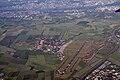
 Wiesbaden District - Aerial Scenery - geo.hlipp.de - 27535.jpg 640 × 480; 53 KB
-
 Wiesbaden District - Aeriel Scenery - geo.hlipp.de - 27534.jpg 640 × 480; 67 KB
-
 Wiesbaden District - Bundesautobahn 3 - geo.hlipp.de - 27536.jpg 480 × 640; 50 KB
-

-

-

-

-

-

-


.jpg)
.jpg)

.jpg)


.jpg)
.jpg)


_(WIE_-_ETOU)_AN0871664.jpg)
_(WIE_-_ETOU)_AN1975382.jpg)


.jpg)