Category:Air traffic control
Jump to navigation
Jump to search
service provided for the purpose of preventing collisions between aircraft, and on the manoeuvring area between aircraft and obstructions; and expediting and maintaining an orderly flow of air traffic | |||||
| Upload media | |||||
| Spoken text audio | |||||
|---|---|---|---|---|---|
| Subclass of |
| ||||
| Part of | |||||
| |||||
Subcategories
This category has the following 25 subcategories, out of 25 total.
A
- ADOC (Iran) (12 F)
- Aerobeacons (13 F)
- Airfield marks (3 F)
C
F
- Flight Deck Officer (2 F)
- Flight progress strips (7 F)
H
- Holding pattern (40 F)
L
- Landing Signal Officer (179 F)
M
- Maps of air traffic control (13 F)
N
O
P
- Procedure turn (1 F)
R
S
T
- Tower Simulation System (2 F)
U
- United Kingdom Low Flying System (127 F)
V
- Air traffic control vehicles (27 F)
Media in category "Air traffic control"
The following 148 files are in this category, out of 148 total.
-
 1 L6Y4NHu wFCnpfBu-Aa1cA.gif 1,200 × 584; 20.84 MB
-
 2016 Niederhermsdorf Antenne Flugsicherung.jpg 4,089 × 2,306; 2.03 MB
-
 241 Emblem.jpg 3,270 × 3,732; 671 KB
-
 5D896188A622C1.png 1,024 × 384; 9 KB
-
 711 squadron RNLAF "Oculus patriam custodiens".jpg 617 × 926; 768 KB
-

-

-
-
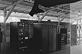
 9020 Complex IBM360.JPG 2,900 × 1,410; 989 KB
-
 A90 BOS Area.JPG 1,186 × 1,146; 136 KB
-
 A90 Scope.jpg 746 × 780; 128 KB
-
 Aasiaat Airport (27422884182).jpg 4,200 × 2,790; 5.51 MB
-
 AF Combat Controller provides air traffic control to Hurlburt Field.jpg 3,008 × 1,960; 889 KB
-
 AF Combat Controllers clear C-130 in Afghanistan.jpg 2,544 × 1,688; 4.38 MB
-
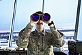 Air traffic control binoculars.jpg 4,930 × 3,280; 1.94 MB
-

-
Air traffic control tower Bangalore International Airport.webm 15 s, 1,080 × 606; 4.01 MB
-
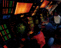
 Air traffic controller Skyguide at Airport Zurich.jpg 1,200 × 800; 585 KB
-
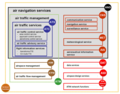
 Air Traffic Management.jpg 1,224 × 792; 696 KB
-
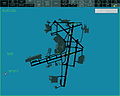
 Airports Network Map.png 6,230 × 3,444; 11.57 MB
-
 Airspace.png 841 × 619; 595 KB
-
 Allocation de niveau de vol pour la déconfliction de trajectoires 4D.pdf 1,239 × 1,752, 67 pages; 1.17 MB
-
 Apparatuur, Bestanddeelnr 1437.jpg 3,792 × 2,494; 1.58 MB
-
 Apparatuur, Bestanddeelnr 1441.jpg 3,771 × 2,485; 1.76 MB
-
 Archumb.jpg 330 × 248; 51 KB
-
 ARO signal.jpg 215 × 185; 9 KB
-
 Asde-x display.jpg 640 × 502; 47 KB
-
 ATC Rally 011019 (23 of 33) (46776818481).jpg 6,720 × 4,480; 1.72 MB
-
 ATC Tower Zis-151 (15334172216).jpg 1,200 × 1,202; 1.22 MB
-
 ATMANS.png 800 × 627; 209 KB
-
 AWE1549 FAA Transcript.pdf 1,275 × 1,650, 9 pages; 309 KB
-
 Bell telephone magazine (1922) (14756123082).jpg 2,074 × 1,672; 940 KB
-
 BORYSPIL TOWER - panoramio.jpg 2,856 × 2,142; 1.42 MB
-
 Bundeswehr (Heer) - Funkplätze in einem VW T4.JPG 2,624 × 1,496; 911 KB
-
 Bundeswehr - VW T4 (Heer, Flugsicherung).JPG 3,648 × 2,736; 4.14 MB
-
 Cabina de Control para tráfico aéreo - A742589.jpg 6,966 × 4,184; 13.94 MB
-
 Cabina de Control para tráfico aéreo - A742602.jpg 4,916 × 4,672; 11.98 MB
-
 CBP unmanned aerial vehicle control.jpg 2,408 × 1,563; 326 KB
-
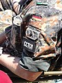 CCT01.JPG 2,736 × 3,648; 3.46 MB
-
 Centro de Controle de Área (controlador aéreo).png 304 × 285; 151 KB
-
 Colorado -Adams County - Las Animas County (part)- - NARA - 17443770 (page 1516).jpg 1,624 × 2,056; 487 KB
-
Controle voor luchtverkeer-520070.ogv 2 min 14 s, 768 × 576; 23 MB
-
 Deister-vdf.jpg 1,200 × 1,600; 578 KB
-
 Deutsche Flugsicherung Funkfeuer Hamburg-Lemsahl.jpg 750 × 1,000; 481 KB
-
 DFS headquarters in Langen.jpeg 1,758 × 1,273; 2.29 MB
-
 Dreieich 07.08 010.jpg 1,600 × 1,200; 361 KB
-
 FAA mobile control tower & equipment loaded onto Antonov An-124 at HST 2010-01-21 1.JPG 4,288 × 2,848; 4.13 MB
-
 Fade regions.jpg 1,962 × 1,081; 249 KB
-
-
Flugzeugsicherheit – doppelt hält besser.webm 32 s, 1,920 × 1,080; 34.66 MB
-
 GOVERNMENT AND INDUSTRY-WIDE EFFORTS TO ADDRESS AIR TRAFFIC CONTROL DELAYS (IA gov.gpo.fdsys.CHRG-107shrg88830).pdf 1,275 × 1,650, 59 pages; 1.76 MB
-
 HalsDtop1.png 1,600 × 1,200; 97 KB
-
 HalsDtop11.png 1,200 × 1,200; 58 KB
-
 HoustonAirTrafficControlCenter.jpg 172 × 229; 6 KB
-
 Iads-display full.jpg 1,920 × 1,425; 1.01 MB
-
 Icao flight plan.jpg 900 × 1,231; 280 KB
-
 IFRLFMN.jpg 1,024 × 683; 450 KB
-
 IM--1337---The-Women-Marines'-Third-Warsm.jpg 800 × 600; 86 KB
-
 Image radar USA.jpg 640 × 512; 75 KB
-
 Interag holding.png 508 × 379; 14 KB
-

-

-
 Isfahan International Airport 07.jpg 800 × 491; 159 KB
-
 Jacksonville 9020.jpg 862 × 658; 135 KB
-
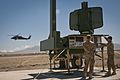
 JASDF Mobile Radar Approach Control System at Miho Air Base May 27, 2018 01.jpg 4,000 × 2,251; 2.1 MB
-
 JASDF Mobile Radar Approach Control System at Miho Air Base May 27, 2018 02.jpg 4,000 × 2,251; 2.01 MB
-
 JASDF Mobile Radar Approach Control System at Miho Air Base May 27, 2018 03.jpg 4,000 × 2,251; 1.91 MB
-
 JASDF Mobile Radar Approach Control System at Miho Air Base May 27, 2018 04.jpg 5,568 × 3,712; 4.81 MB
-
 Joint Operations Centre Cannerberg (10).jpg 2,500 × 1,644; 945 KB
-
 Joint Operations Centre Cannerberg (11).jpg 2,500 × 1,643; 888 KB
-
 Joint Operations Centre Cannerberg (11a).jpg 2,500 × 1,652; 644 KB
-
 Jordan Croft at Springfest.jpg 720 × 540; 88 KB
-
 K-29 trailer for SCR-277 radio navigation.jpg 1,089 × 826; 632 KB
-
 Kerben Airport ATC.jpg 5,472 × 3,072; 5.63 MB
-
 La Dôle - panoramio (64).jpg 2,848 × 4,272; 7.09 MB
-
 La Dôle - panoramio (80).jpg 4,272 × 2,848; 8.16 MB
-
 La Dôle - panoramio (94).jpg 2,848 × 4,272; 9.88 MB
-
 Lajes Field Air Traffic Control.jpg 6,048 × 4,024; 3.58 MB
-
 LATCC 9020.png 2,328 × 1,795; 2.99 MB
-
 Lelystad Flugsimulatorwochenende 20091107 244.JPG 2,848 × 4,272; 4.97 MB
-
 Lennonjohtaja Fredrik Lehto Helsingin aluelennonjohdossa 1950-luvulla.jpg 679 × 1,080; 61 KB
-
 Longsep1.png 700 × 500; 21 KB
-
 Longsep2.png 700 × 500; 25 KB
-
 Longsep3.png 700 × 500; 35 KB
-
 MAKS Airshow 2013 (9639221228).jpg 4,928 × 3,264; 3.84 MB
-
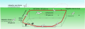
 Map of the worldwide air traffic control radar coverag.png 1,879 × 953; 220 KB
-
 Map of the worldwide coverage of High Frequency network.png 1,500 × 740; 46 KB
-
 Masten Flugsicherung Lemsahl.JPG 1,036 × 832; 75 KB
-
 Meydan Trafik Bölgesi ATZ ve MATZ.png 1,340 × 759; 58 KB
-
 Miami Tower in 1994- c5491a8e509e63.jpg 2,840 × 1,870; 613 KB
-
 Milano radar vatsim.jpg 1,920 × 1,059; 395 KB
-
 MSN7 Tarkio.jpg 3,008 × 2,000; 2.57 MB
-
 Napoli radar IVAO.jpg 1,257 × 943; 473 KB
-
 NAT HLA map.png 547 × 775; 216 KB
-
 NAT-Tracks-24FEB17.png 2,866 × 1,434; 1.84 MB
-
 NAT.png 1,187 × 606; 408 KB
-
 National Air Traffic Controllers Association.jpg 3,456 × 4,608; 4.67 MB
-
 NavCanada FSS in Thompson.jpg 2,592 × 1,944; 2.17 MB
-
 NewarkAirportControlTower 01.jpg 1,728 × 2,304; 965 KB
-
Nieuwe radarinstallatie Weeknummer 51-45 - Open Beelden - 22767.ogv 2 min 18 s, 352 × 288; 16.91 MB
-
 Oslo Airport, Fornebu radar 1.jpg 800 × 631; 367 KB
-
 Oslo Airport, Fornebu radar 2.jpg 800 × 623; 328 KB
-
 PAM final switch off.jpg 909 × 1,299; 681 KB
-
 Paul + auditorium MGF1254.jpg 4,187 × 2,692; 1.86 MB
-
 Pbn.png 641 × 365; 24 KB
-
 PMR ATC Tower1.jpg 3,211 × 3,211; 1.47 MB
-
 Pupitre controle aéronautique.jpg 4,032 × 3,024; 2.2 MB
-
 Rnp.png 675 × 306; 7 KB
-
 Runway diagram night.png 801 × 83; 7 KB
-
 Runway diagram night.svg 801 × 83; 19 KB
-
-
 SalleCRNA.jpg 198 × 140; 27 KB
-
 SCP AtSK Progress.jpeg 2,288 × 1,712; 755 KB
-
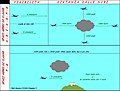
 Sep later FIX.png 508 × 379; 13 KB
-
 Sep later NDB.png 508 × 379; 12 KB
-
 Sep later VOR.png 508 × 379; 12 KB
-
 Separation atc.png 145 × 202; 5 KB
-
September 11, 2001 ATC in real time (FAA-NORAD audio).ogv 1 h 51 min 31 s, 1,280 × 720; 1.87 GB
-
 Shannon Air Traffic Control Centre.jpg 4,730 × 2,078; 2.51 MB
-
 Shannon Airport Control Tower.jpg 4,160 × 2,773; 2.56 MB
-
 Sistemacnsatm.JPG 982 × 684; 66 KB
-
 SSEP-DISPLAY.png 864 × 1,134; 133 KB
-
 Stanleyairport2.JPG 2,592 × 1,944; 1.45 MB
-
 Sum & difference.jpg 1,107 × 891; 51 KB
-
 TACAN.jpg 1,063 × 589; 171 KB
-
 Taxiways.png 289 × 271; 23 KB
-
 Taxiways.svg 650 × 650; 30 KB
-
 TokorozawaCommunicationsTower.jpg 600 × 800; 281 KB
-
 Tokyo Air Traffic Control Dept. 1.jpg 2,560 × 1,920; 1.11 MB
-
 Tr de piste.svg 1,378 × 470; 702 KB
-
 TRACON DFW.gif 301 × 238; 31 KB
-
 Trafic aérien 2004.png 698 × 331; 10 KB
-

-
 Transportation-3.jpg 600 × 480; 32 KB
-
 UAS traffic management image.png 1,000 × 1,000; 236 KB
-
 Unbekanntes Objekt - panoramio.jpg 2,048 × 1,536; 1,007 KB
-
 Vertical separation.png 205 × 156; 2 KB
-
-
 Visual Meteo Conditions.jpg 869 × 657; 87 KB
-
 VORDME vs RNAV approaching model.PNG 1,160 × 600; 52 KB
-
 VORDME vs RNAV model.PNG 960 × 860; 61 KB
-
 VRC Screenshot.PNG 1,279 × 993; 208 KB
-
 Wellington ATC Tower.jpg 4,550 × 4,993; 9.59 MB
-
 ZAN-ARTCC.jpg 250 × 125; 6 KB
-
 Übung zur Mitschrift einer Freigabe der Flugverkehrskontrolle 2013 PD.jpg 3,239 × 2,828; 6.84 MB
-
 КДП аэродрома Гатчина.jpg 2,339 × 1,518; 473 KB
-
 КДП.jpg 1,742 × 1,150; 529 KB
-
 Шюл4.JPG 2,578 × 2,112; 3.56 MB


.jpg)


_(46776818481).jpg)
.jpg)

_(14756123082).jpg)

_-_Funkpl%C3%A4tze_in_einem_VW_T4.JPG)
.JPG)


.png)
-_-_NARA_-_17443770_(page_1516).jpg)


.jpg)
.jpg)


.jpg)
.jpg)
.jpg)


.jpg)
.jpg)
.jpg)


.jpg)


