Category:Airspace
Jump to navigation
Jump to search
portion of the atmosphere controlled by a country | |||||
| Upload media | |||||
| Instance of |
| ||||
|---|---|---|---|---|---|
| Subclass of |
| ||||
| Part of | |||||
| Different from | |||||
| |||||
Subcategories
This category has the following 4 subcategories, out of 4 total.
Media in category "Airspace"
The following 18 files are in this category, out of 18 total.
-
 601st Air and Space Operations Center.jpg 2,100 × 1,406; 1.76 MB
-
 Aegean 10 nm.svg 432 × 467; 225 KB
-
 Airspace museum - panoramio (1).jpg 2,464 × 1,632; 769 KB
-
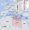
 Coalition action against Libya mk.svg 972 × 1,022; 836 KB
-
 Coalition action against Libya-ItalianNavyAdded.svg 972 × 1,022; 2.4 MB
-
 Dual Use of Commercial Avionics Data Links for the U. S. Air Force.pdf 1,275 × 1,650, 5 pages; 131 KB
-
 FLYING UNDER THE RADAR- SECURING WASHINGTON, D.C., AIRSPACE (IA gov.gpo.fdsys.CHRG-114hhrg95250).pdf 1,275 × 1,650, 88 pages; 1.67 MB
-
 IASTA-2007-map.svg 940 × 477; 1.53 MB
-
 Minimum Safe Altitude.gif 260 × 260; 60 KB
-
 Operation Odyssey Dawn - No Fly Zone - Libya March 2011.jpg 678 × 689; 335 KB
-
 Overflight Permit Map.png 2,270 × 1,256; 442 KB
-
 Radiative Forcing in Aviation 1992.png 3,329 × 2,023; 52 KB
-
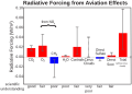 Radiative Forcing in Aviation 1992.svg 897 × 641; 29 KB
-
 Radiační působení emisí z letectví.svg 897 × 641; 34 KB
-
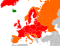
 Travel crisis in Europe 2010.png 1,200 × 1,000; 42 KB
-
 Travel crisis in Europe 2010.svg 680 × 520; 737 KB
-
 US airspace visibility 2016.jpg 959 × 734; 203 KB
-
 領土領海領空.svg 600 × 550; 37 KB


.jpg)


