Category:Aizanoi Roman bridge (south)
Jump to navigation
Jump to search
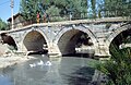
The southern of the two surviving Roman bridges over the Penkalas river at Aizanoi (bridge 2 in the plans of the site by the Deutsches Archäologisches Institut), located southeast of the Temple of Zeus on Taksim Caddesi.
| Object location | | View all coordinates using: OpenStreetMap |
|---|
bridge in Aezani, Turkey  | |||||
| Upload media | |||||
| Instance of | |||||
|---|---|---|---|---|---|
| Made from material | |||||
| Location | |||||
 | |||||
Media in category "Aizanoi Roman bridge (south)"
The following 4 files are in this category, out of 4 total.
-
 Aizanoi Penkalas Bridge june 2008 2316.jpg 1,600 × 1,065; 720 KB
-
 Aizanoi Penkalas Bridge june 2008 2317.jpg 1,600 × 1,065; 690 KB
-
 Aizanoi Roman bridge from SW (1993).jpg 4,619 × 3,060; 3.77 MB
-
 AizanoiBrücke.jpg 1,997 × 1,303; 2.57 MB


.jpg)