Category:Alciston
Jump to navigation
Jump to search
village and civil parish in the Wealden district of East Sussex, England  | |||||
| Upload media | |||||
| Instance of | |||||
|---|---|---|---|---|---|
| Located in protected area | |||||
| Location | Wealden, East Sussex, South East England, England | ||||
| Area |
| ||||
 | |||||
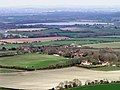
English: Alciston ) is a village and civil parish in the Wealden district of East Sussex, England. It is inland, just off the A27 road, about ten miles (16 km) north-west of Eastbourne and seven miles (11 km) east of Lewes. The ecclesiastical parish is linked with that of Selmeston and Berwick.
Français : Alciston est une commune d' Angleterre située dans le comté du Sussex de l'Est et dans le district de Wealden.
Subcategories
This category has the following 8 subcategories, out of 8 total.
A
- Alciston Dovecote (5 F)
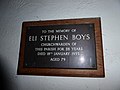
- Alciston World War I Plaque (2 F)
B
- Bostal Hill, Alciston (7 F)
C
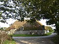
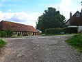
- Court Farm, Alciston (3 F)
R
S
T
- Tithe Barn, Alciston (6 F)
Media in category "Alciston"
The following 200 files are in this category, out of 324 total.
(previous page) (next page)-
 A Sheep and her lambs, Bostal Hill - geograph.org.uk - 1828780.jpg 640 × 430; 139 KB
-
 A small enclosure by The South Downs Way - geograph.org.uk - 1828738.jpg 640 × 430; 137 KB
-
 A View at Dusk - geograph.org.uk - 1981489.jpg 1,024 × 768; 198 KB
-
 A27 Lewes Road junction with The Village - geograph.org.uk - 3008070.jpg 3,487 × 2,632; 1.19 MB
-
 A27 Lewes Road, Selmeston - geograph.org.uk - 2843743.jpg 4,320 × 3,240; 3.83 MB
-
 A27 Lewes Road, Selmeston - geograph.org.uk - 2843748.jpg 4,320 × 3,240; 3.75 MB
-
 A27 near Alciston - geograph.org.uk - 4923137.jpg 3,264 × 1,840; 1.98 MB
-
 After the ride - geograph.org.uk - 6281981.jpg 640 × 480; 84 KB
-
 Alciston - geograph.org.uk - 5969638.jpg 1,024 × 768; 349 KB
-
 Alciston Church - geograph.org.uk - 5091267.jpg 2,048 × 1,536; 564 KB
-
 Alciston Church at twilight - geograph.org.uk - 4760307.jpg 640 × 480; 56 KB
-
 Alciston Church, CWGC grave - geograph.org.uk - 4764243.jpg 480 × 640; 59 KB
-
-

-
 Alciston Church, organ - geograph.org.uk - 4764527.jpg 480 × 640; 60 KB
-
 Alciston Dovecote - geograph.org.uk - 5091265.jpg 2,048 × 1,536; 738 KB
-
 Alciston from Bo-Peep Lane - geograph.org.uk - 2879284.jpg 1,600 × 1,200; 417 KB
-
 Alciston from Bostal Hill - geograph.org.uk - 109292.jpg 640 × 315; 55 KB
-
 Alciston from Bostal Hill - geograph.org.uk - 2879288.jpg 1,600 × 1,200; 342 KB
-
 Alciston from the South Downs.jpg 5,660 × 3,107; 3.96 MB
-
 Alciston Great Barn - geograph.org.uk - 6186675.jpg 4,682 × 2,578; 3.13 MB
-
 Alciston parish church - geograph.org.uk - 3467385.jpg 1,600 × 1,060; 509 KB
-
 Alciston Tithe Barn - geograph.org.uk - 5091270.jpg 2,048 × 1,536; 649 KB
-
 Alciston Tithe Barn - geograph.org.uk - 5091273.jpg 2,048 × 1,536; 644 KB
-
 Alciston tithe barn - geograph.org.uk - 5523656.jpg 1,024 × 768; 250 KB
-
 Alciston tithe barn, cart entrance and roof - geograph.org.uk - 5523716.jpg 763 × 1,024; 297 KB
-
 Alciston tithe barn, from the west - geograph.org.uk - 5523555.jpg 1,024 × 772; 326 KB
-
 Alciston tithe barn, reflected - geograph.org.uk - 5522685.jpg 768 × 1,024; 202 KB
-
 Alciston tithe barn, window detail (with horse) - geograph.org.uk - 5522668.jpg 768 × 1,024; 241 KB
-
 Alciston, Mill Hill cottage.jpg 3,000 × 2,003; 2.13 MB
-
 Alciston, triangular wooden bench.jpg 2,000 × 1,332; 1.06 MB
-
 Animal Pen along South Downs Way - geograph.org.uk - 2111502.jpg 640 × 480; 91 KB
-
 Approaching Bopeep - geograph.org.uk - 1832310.jpg 640 × 480; 44 KB
-
 Arborial Archway, Bo Peep Lane - geograph.org.uk - 962427.jpg 640 × 479; 112 KB
-
 At home on the downs - geograph.org.uk - 1828728.jpg 640 × 430; 121 KB
-
 At the top of Bopeep Bostall - geograph.org.uk - 2652558.jpg 4,000 × 3,000; 4.06 MB
-
 Avenue of trees on road to Stonery Farm - geograph.org.uk - 3026221.jpg 4,000 × 3,000; 3.55 MB
-
 Bambridge Furlong - geograph.org.uk - 1980501.jpg 1,024 × 768; 299 KB
-
 Barley Mow - geograph.org.uk - 2105146.jpg 480 × 640; 98 KB
-
 Bench with a view, Bo-Peep - geograph.org.uk - 1828751.jpg 640 × 430; 138 KB
-
 Benches, Bo-Peep - geograph.org.uk - 1828753.jpg 640 × 430; 132 KB
-
 Bend on the A27 - geograph.org.uk - 2840844.jpg 640 × 480; 56 KB
-
 Between Firle Beacon and Bostal Hill - geograph.org.uk - 2963512.jpg 2,816 × 2,112; 1.89 MB
-
 Bo Peep Borstal - geograph.org.uk - 6429504.jpg 5,064 × 3,439; 4.22 MB
-
 Bo Peep Bostal - geograph.org.uk - 961646.jpg 469 × 640; 92 KB
-
 Bo Peep Bostal - geograph.org.uk - 962410.jpg 640 × 479; 122 KB
-
 Bo Peep Chalk Pit - geograph.org.uk - 962457.jpg 479 × 640; 121 KB
-
 Bo Peep Cottage, Bo Peep Bostal - geograph.org.uk - 962418.jpg 640 × 479; 171 KB
-
 Bo Peep Farm - geograph.org.uk - 962447.jpg 640 × 479; 98 KB
-
 Bo-Peep Bostal - geograph.org.uk - 1828744.jpg 640 × 430; 123 KB
-
 Bopeep Bostal - geograph.org.uk - 2111510.jpg 640 × 480; 177 KB
-
 Bopeep Bostel - geograph.org.uk - 5802139.jpg 4,152 × 3,704; 5.58 MB
-
 Bopeep Car Park - geograph.org.uk - 1979020.jpg 1,024 × 768; 201 KB
-
 Bopeep Chalk Pit - geograph.org.uk - 6281987.jpg 640 × 480; 90 KB
-
 Bopeep Chalk Pit - geograph.org.uk - 6281994.jpg 640 × 480; 95 KB
-
 Bopeep Cottage - geograph.org.uk - 5969634.jpg 1,024 × 768; 325 KB
-
 Bopeep Farm - geograph.org.uk - 1832995.jpg 640 × 480; 106 KB
-
 Bopeep Farm - geograph.org.uk - 3024628.jpg 4,000 × 3,000; 3.43 MB
-
 Bopeep Lane - geograph.org.uk - 1979870.jpg 768 × 1,024; 244 KB
-
 Borstal Bottom - geograph.org.uk - 1828760.jpg 640 × 430; 115 KB
-
 Bostal Hill - geograph.org.uk - 1981462.jpg 1,024 × 768; 146 KB
-
 Bostal Hill - geograph.org.uk - 3839002.jpg 3,072 × 2,048; 1.48 MB
-
 Bostal Hill - geograph.org.uk - 962388.jpg 479 × 640; 75 KB
-
 Bostal Hill tumulus - geograph.org.uk - 4609657.jpg 1,142 × 857; 329 KB
-

-
 Bowl barrows in two barrow cemeteries southeast of Firle Beacon 01.jpg 4,000 × 3,000; 6.8 MB
-
 Bowl barrows in two barrow cemeteries southeast of Firle Beacon 02.jpg 4,000 × 3,000; 6.8 MB
-
 Bowl barrows in two barrow cemeteries southeast of Firle Beacon 03.jpg 4,000 × 3,000; 6.4 MB
-
 Bowl barrows in two barrow cemeteries southeast of Firle Beacon 04.jpg 4,000 × 3,000; 6.42 MB
-
 Bowl barrows in two barrow cemeteries southeast of Firle Beacon 05.jpg 4,000 × 3,000; 6.24 MB
-
 Bridleway above Bostal Bottom - geograph.org.uk - 2979109.jpg 4,000 × 3,000; 3.72 MB
-
 Bridleway across crops to the South Downs Way - geograph.org.uk - 2902132.jpg 4,000 × 3,000; 2.96 MB
-
 Bridleway across rape field - geograph.org.uk - 3490781.jpg 640 × 480; 120 KB
-
 Bridleway Alciston 15c to South Heighton - geograph.org.uk - 2979275.jpg 4,000 × 3,000; 3.47 MB
-
 Bridleway cross roads in wheat field - geograph.org.uk - 2979121.jpg 4,000 × 3,000; 3.38 MB
-
 Bridleway from Bostal Hill - geograph.org.uk - 2105256.jpg 640 × 427; 70 KB
-
 Bridleway from Bostal Hill car park - geograph.org.uk - 2105237.jpg 640 × 427; 88 KB
-

-

-
 Bridleway post on the South Downs Way - geograph.org.uk - 2977374.jpg 4,000 × 3,000; 3.53 MB
-
 Bridleway signpost - geograph.org.uk - 1828786.jpg 640 × 430; 112 KB
-
 Bridleway to Bo Peep Bostal - geograph.org.uk - 962391.jpg 475 × 640; 112 KB
-
 Bridleway to Denton - geograph.org.uk - 2105306.jpg 640 × 427; 93 KB
-
 Bridleway to Tilton - geograph.org.uk - 1979129.jpg 1,024 × 768; 289 KB
-
 Bridleway to Tilton Farm - geograph.org.uk - 961596.jpg 640 × 465; 110 KB
-
 Broadlands Furlong - geograph.org.uk - 1980401.jpg 1,024 × 768; 198 KB
-
 Car Park at Bo-Peep - geograph.org.uk - 1828749.jpg 640 × 430; 117 KB
-
 Car Park near Bopeep Farm - geograph.org.uk - 3116265.jpg 1,600 × 1,064; 614 KB
-
 Chalk escarpment near to Bostal Hill - geograph.org.uk - 2613614.jpg 3,968 × 2,976; 2.74 MB
-
 Common Lane, eastward - geograph.org.uk - 1816562.jpg 640 × 430; 106 KB
-
 Common Lane, westward - geograph.org.uk - 1816561.jpg 640 × 430; 126 KB
-
 Corn Field by Bopeep Lane - geograph.org.uk - 2111282.jpg 640 × 427; 112 KB
-
 Corn Field near Upper Barn - geograph.org.uk - 2105225.jpg 640 × 427; 103 KB
-
 Covered reservoir at Alciston - geograph.org.uk - 3024746.jpg 4,000 × 3,000; 3.4 MB
-
 Cropland off Common Lane - geograph.org.uk - 2108344.jpg 640 × 480; 91 KB
-
 Cropland off Common Lane - geograph.org.uk - 2108356.jpg 640 × 279; 61 KB
-
 Cycling to Bopeep - geograph.org.uk - 4332578.jpg 640 × 480; 56 KB
-
 Cyclists on The South Downs Way - geograph.org.uk - 1828775.jpg 640 × 430; 104 KB
-
 Degraded tumulus, Borstal Hill - geograph.org.uk - 1828765.jpg 640 × 430; 123 KB
-
 Dip in field on the South Downs - geograph.org.uk - 2111517.jpg 640 × 480; 101 KB
-
 Distant view of Firle Round Hill - geograph.org.uk - 4923097.jpg 3,264 × 1,840; 1.69 MB
-
 Disused Chalk Pit near Bopeep - geograph.org.uk - 1979174.jpg 1,024 × 768; 211 KB
-
 Downs View Farm from Stonery Farm - geograph.org.uk - 1816544.jpg 640 × 430; 138 KB
-
 Edge of Bopeep Quarry, Alciston, East Sussex - geograph.org.uk - 1847567.jpg 1,600 × 1,200; 415 KB
-
 Eleven Acre Boro - geograph.org.uk - 1980276.jpg 1,024 × 768; 276 KB
-
 Farm entrance, Common Lane - geograph.org.uk - 1816557.jpg 640 × 430; 143 KB
-
 Farm track into Tilton Bottom - geograph.org.uk - 2902139.jpg 4,000 × 3,000; 3.67 MB
-
 Farmland at Alciston - geograph.org.uk - 2625523.jpg 640 × 480; 103 KB
-
 Farmland by Bobeep Bostal - geograph.org.uk - 2625527.jpg 640 × 480; 109 KB
-
 Farmland near Alciston - geograph.org.uk - 2620800.jpg 8,600 × 2,254; 7.64 MB
-
 Fence around Tumuli on the South Downs Way - geograph.org.uk - 2977285.jpg 4,000 × 3,000; 3.58 MB
-
 Fence on the Northern Escarpment - geograph.org.uk - 962357.jpg 640 × 457; 83 KB
-
 Fenced Off Area next to South Downs Way - geograph.org.uk - 961611.jpg 640 × 479; 100 KB
-
 Field below the Downs at Selmeston - geograph.org.uk - 2436371.jpg 1,600 × 1,200; 612 KB
-
 Field boundary fences below Bopeep - geograph.org.uk - 4332564.jpg 640 × 427; 61 KB
-
 Field South of Tilton Wood - geograph.org.uk - 962464.jpg 640 × 479; 100 KB
-
 Fields below the South Downs - geograph.org.uk - 2111514.jpg 640 × 480; 124 KB
-
 Fields beside Bopeep Lane - geograph.org.uk - 2105169.jpg 640 × 480; 86 KB
-
 Fields on the South Downs - geograph.org.uk - 2118859.jpg 640 × 480; 95 KB
-
 Fields round Alciston - geograph.org.uk - 1833002.jpg 640 × 480; 70 KB
-

-
 Filling Station and Store - geograph.org.uk - 2105141.jpg 640 × 427; 90 KB
-
 Firle Beacon - geograph.org.uk - 3839033.jpg 640 × 427; 71 KB
-
 Footpath down the South Downs - geograph.org.uk - 2105176.jpg 640 × 480; 86 KB
-
 Footpath Junction near Firle - geograph.org.uk - 5090709.jpg 4,896 × 3,672; 5.47 MB
-
 Footpath Junction Sign at Bopeep Borstal - geograph.org.uk - 5091262.jpg 2,048 × 1,536; 869 KB
-
 Footpath through Public Access Land - geograph.org.uk - 5090702.jpg 4,896 × 3,672; 5.78 MB
-
 Footpath to Alciston Church - geograph.org.uk - 3024739.jpg 4,000 × 3,000; 3.53 MB
-
 Footpath to Horseshoe Wood - geograph.org.uk - 962380.jpg 473 × 640; 95 KB
-
 Footpath to the Old Coach Road - geograph.org.uk - 961660.jpg 479 × 640; 171 KB
-
 Gate at end of Public Access Land - geograph.org.uk - 5090706.jpg 4,896 × 3,672; 5.73 MB
-

-
 Gate on The South Downs Way - geograph.org.uk - 1828794.jpg 640 × 430; 121 KB
-
 Gate to Footpath on South Downs Way - geograph.org.uk - 5091263.jpg 2,048 × 1,536; 813 KB
-
-
 Gorse on top of The South Downs - geograph.org.uk - 1828732.jpg 640 × 430; 128 KB
-
 Great Boro (1) - geograph.org.uk - 1980242.jpg 1,024 × 768; 233 KB
-
 Great Boro (2) - geograph.org.uk - 1980273.jpg 1,024 × 768; 238 KB
-
 Great Common - geograph.org.uk - 1979737.jpg 1,024 × 768; 265 KB
-
 Great Gardens - geograph.org.uk - 1980292.jpg 1,024 × 768; 263 KB
-
 Great Meadow - geograph.org.uk - 1979261.jpg 1,024 × 768; 263 KB
-
 Hedge off The Vanguard Way, Stonery Farm - geograph.org.uk - 1816551.jpg 640 × 430; 143 KB
-
 Hedges around Small Field - geograph.org.uk - 4923087.jpg 3,264 × 1,840; 1.28 MB
-
 High Meadow - geograph.org.uk - 1979235.jpg 1,024 × 768; 311 KB
-
 Hikers, Bostal Hill near Selmeston - geograph.org.uk - 3578978.jpg 1,024 × 467; 107 KB
-
 Horse guarding the path to Alciston Church - geograph.org.uk - 5117455.jpg 4,608 × 3,456; 3.42 MB
-
 Horse Rider on South Downs - geograph.org.uk - 2111499.jpg 640 × 427; 63 KB
-
 Horse Riding down the South Downs - geograph.org.uk - 2118928.jpg 640 × 480; 131 KB
-
 Horseshoe Wood - geograph.org.uk - 2625510.jpg 640 × 480; 159 KB
-
 Horseshoe Wood - geograph.org.uk - 962401.jpg 479 × 640; 166 KB
-
 Hot food van in lay-by, Selmeston, West Sussex - geograph.org.uk - 2326376.jpg 1,600 × 1,159; 235 KB
-
 Housing at Bopeep Farm - geograph.org.uk - 3024641.jpg 4,000 × 3,000; 3.46 MB
-
 Information Board, Bo-Peep - geograph.org.uk - 1828754.jpg 640 × 430; 125 KB
-
 Inside Alciston Church (i) - geograph.org.uk - 4764249.jpg 640 × 480; 36 KB
-
 Inside Alciston Church (ii) - geograph.org.uk - 4764528.jpg 480 × 640; 60 KB
-
 Inside Alciston Church (iii) - geograph.org.uk - 4764737.jpg 480 × 640; 40 KB
-
 Inside Alciston Church (iv) - geograph.org.uk - 4764738.jpg 478 × 640; 62 KB
-
 Inside Alciston Church (ix) - geograph.org.uk - 4764744.jpg 471 × 640; 62 KB
-
 Inside Alciston Church (v) - geograph.org.uk - 4764740.jpg 480 × 640; 63 KB
-
 Inside Alciston Church (vi) - geograph.org.uk - 4764741.jpg 480 × 640; 33 KB
-
 Inside Alciston Church (vii) - geograph.org.uk - 4764742.jpg 640 × 480; 32 KB
-
 Inside Alciston Church (viii) - geograph.org.uk - 4764743.jpg 640 × 467; 48 KB
-
 Interior of Alciston Church - geograph.org.uk - 5117467.jpg 4,608 × 3,456; 3.32 MB
-
 Jerry's Bottom - geograph.org.uk - 1828783.jpg 640 × 430; 110 KB
-
 Layby on the A27 - geograph.org.uk - 3023274.jpg 4,000 × 3,000; 3.68 MB
-
 Little Sturtles - geograph.org.uk - 1979920.jpg 1,024 × 768; 227 KB
-

-
 Looking back towards Bostal Hill - geograph.org.uk - 2613617.jpg 3,968 × 2,976; 2.75 MB
-

-

-
 Looking south-ish over wheat field to Bostal Bottom - geograph.org.uk - 2902138.jpg 4,000 × 3,000; 3.77 MB
-
 Looking towards the Bo Peep Car Park - geograph.org.uk - 732147.jpg 640 × 366; 64 KB
-
 Memorial bench, Bopeep, near Alciston - geograph.org.uk - 1847571.jpg 1,600 × 1,200; 513 KB
-
 Memorial in Alciston Church - geograph.org.uk - 5117476.jpg 4,493 × 3,371; 2.39 MB
-
 Middle Cow Field - geograph.org.uk - 1979964.jpg 1,024 × 768; 207 KB
-
 Mill Hill (1) - geograph.org.uk - 1979830.jpg 1,024 × 768; 316 KB
-
 Mill Hill (2) - geograph.org.uk - 1979846.jpg 1,024 × 768; 277 KB
-
 National Trail and Tumulus on Bostal Hill - geograph.org.uk - 2963519.jpg 2,708 × 2,100; 1.4 MB
-
 New Pond - geograph.org.uk - 1981470.jpg 1,024 × 768; 170 KB
-
 New Pond and Tumuli on Bostal Hill - geograph.org.uk - 2977382.jpg 4,000 × 3,000; 3.77 MB
-
 Northern Escarpment - geograph.org.uk - 962374.jpg 479 × 640; 70 KB
-
 Old Clergy House, Alciston - geograph.org.uk - 98209.jpg 640 × 428; 172 KB
-
 Old Coach Road - geograph.org.uk - 1980497.jpg 1,024 × 757; 253 KB
-
 Old Coach Road - geograph.org.uk - 961673.jpg 640 × 479; 68 KB
-
 Old Coach Road - geograph.org.uk - 961691.jpg 640 × 479; 95 KB
-
 Old Coach Road - geograph.org.uk - 962430.jpg 479 × 640; 97 KB
-
 Old Coach Road - geograph.org.uk - 962487.jpg 479 × 640; 145 KB
-

-
 Over the fields to Berwick, East Sussex - geograph.org.uk - 3451332.jpg 1,600 × 1,091; 264 KB
-
-
-
 Paragliders, Bo-Peep - geograph.org.uk - 1828758.jpg 640 × 430; 100 KB
-
 Path from Alciston Churchyard back to The Village - geograph.org.uk - 5117458.jpg 4,608 × 3,456; 3.35 MB
-
 Path from the church to the village - geograph.org.uk - 4764745.jpg 480 × 640; 60 KB
-
 Pearson's Wish - geograph.org.uk - 962473.jpg 640 × 488; 119 KB
-
 Pheasant cover - geograph.org.uk - 2562949.jpg 640 × 480; 130 KB
-
 Pond at Alciston, East Sussex - geograph.org.uk - 2438037.jpg 1,600 × 1,200; 436 KB
-
 Pond by Alciston Court - geograph.org.uk - 3024734.jpg 4,000 × 3,000; 3.47 MB
-
 Public footpath sign, Alciston - geograph.org.uk - 3452970.jpg 1,600 × 1,200; 343 KB
-
 Rape oil seed field still in bloom - geograph.org.uk - 3025867.jpg 4,000 × 3,000; 3.48 MB


_-_geograph.org.uk_-_5522668.jpg)


_-_geograph.org.uk_-_1980242.jpg)
_-_geograph.org.uk_-_1980273.jpg)


_-_geograph.org.uk_-_4764249.jpg)
_-_geograph.org.uk_-_4764528.jpg)
_-_geograph.org.uk_-_4764737.jpg)
_-_geograph.org.uk_-_4764738.jpg)
_-_geograph.org.uk_-_4764744.jpg)
_-_geograph.org.uk_-_4764740.jpg)
_-_geograph.org.uk_-_4764741.jpg)
_-_geograph.org.uk_-_4764742.jpg)
_-_geograph.org.uk_-_4764743.jpg)


_-_geograph.org.uk_-_1979830.jpg)
_-_geograph.org.uk_-_1979846.jpg)


