Category:Allée couverte du Parc-Kerdic
Jump to navigation
Jump to search
| Object location | | View all coordinates using: OpenStreetMap |
|---|
|
This building is classé au titre des monuments historiques de la France. It is indexed in the base Mérimée, a database of architectural heritage maintained by the French Ministry of Culture, under the reference PA00089610
|
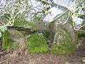
gallery grave in Saint-Connan, France  | |||||
| Upload media | |||||
| Instance of | |||||
|---|---|---|---|---|---|
| Location | Saint-Connan, canton of Saint-Nicolas-du-Pélem | ||||
| Heritage designation |
| ||||
 | |||||
Media in category "Allée couverte du Parc-Kerdic"
This category contains only the following file.
-
 Allée couverte Park-kerdic.jpg 3,456 × 2,592; 767 KB