Category:All-Star Bowling Lanes (Orangeburg, South Carolina)
Jump to navigation
Jump to search
|
This is a category about a place or building that is listed on the National Register of Historic Places in the United States of America. Its reference number is 96000837. |
| Object location | | View all coordinates using: OpenStreetMap |
|---|
bowling alley in South Carolina, U.S.A. _from_S_1.JPG) | |||||
| Upload media | |||||
| Instance of | |||||
|---|---|---|---|---|---|
| Location | Orangeburg, Orangeburg County, South Carolina | ||||
| Street address |
| ||||
| Heritage designation |
| ||||
| Inception |
| ||||
| Significant event |
| ||||
 | |||||
Media in category "All-Star Bowling Lanes (Orangeburg, South Carolina)"
The following 4 files are in this category, out of 4 total.
-
 All-Star Bowling Alley (Orangeburg SC) from S 1.JPG 2,027 × 1,172; 605 KB
-
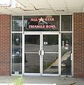 All-Star Bowling Alley (Orangeburg SC) front entrance 1.JPG 1,670 × 1,683; 582 KB
-
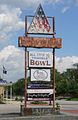 All-Star Bowling Alley (Orangeburg SC) sign from SW 1.JPG 1,243 × 1,920; 522 KB
-
 All-Star Bowling Alley sign detail.JPG 800 × 800; 137 KB
_front_entrance_1.JPG)
_sign_from_SW_1.JPG)
