Category:Almaty Metro maps
Jump to navigation
Jump to search
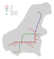
The history of the active development of the Underground in Almaty starts at the beginning of the 1980s. Government solutions have defined the procedure for design and construction – [1]; [2]; [3]. During this period, the original scheme of the Subway several times adjusted – [4]; [5]; [6]. There was also some ideas for further development and improvement – [7]; [8]; [9]; [10]; [11]; [12]; [13]; [14]; [15]; [16]; [17]; [18]; [19]. The search for the optimum development scheme continues – File:THE ALMATY METRO DEVELOPED NETWORK - the Main Scheme (by G.K.Samoilov).pdf.
Media in category "Almaty Metro maps"
The following 26 files are in this category, out of 26 total.
-
 Alamty Metro ru-en.svg 656 × 409; 23 KB
-
 Almatı-metro-map-udm.png 558 × 600; 65 KB
-
 Almaty Metro map (Ukrainian version).png 1,920 × 1,080; 84 KB
-
 Almaty metro map de.svg 744 × 800; 52 KB
-
 Almaty subway scheme 2022.png 1,200 × 849; 233 KB
-
 Almaty-map-metro-depot.svg 744 × 800; 31 KB
-
 Almaty-map-metro.png 1,000 × 1,076; 152 KB
-
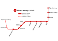
 Almaty-Metro (Linie1).svg 656 × 409; 22 KB
-
 Almaty-metro-map-ru.svg 744 × 800; 51 KB
-
 Almaty-metro-map-ua.svg 744 × 800; 44 KB
-
 Almaty-metro-map-ua2.svg 744 × 800; 44 KB
-
 Almaty-metro-map.svg 744 × 800; 27 KB
-
 Almaty-Metro-Streckenplan (Linie1).png 362 × 226; 9 KB
-
 Ałma-ackie metro.JPG 865 × 735; 68 KB
-
 Ałmaty - Metro.svg 780 × 850; 29 KB
-
 Map.map metro AlmatyБез названия74 20201015132020.png 1,200 × 848; 159 KB
-
 Metro Almaty Linemap 2019.svg 1,400 × 980; 161 KB
-
 U-Bahn Almaty.png 1,920 × 908; 100 KB
-
 Без названия74 20201014182439.png 1,200 × 848; 148 KB
-
 Вторая линия Алматинского метрополитена.svg 744 × 800; 33 KB
-
 Карта метрополитена Алматы (на 2022 год).png 1,920 × 1,080; 89 KB
-
 Карта метрополитена города Алматы (на 2022 год).jpg 1,280 × 720; 49 KB
-
 Карта метрополитена города Алматы (на 2023 год).png 1,280 × 720; 130 KB
-
 Первая линия Алматинского метрополитена.svg 744 × 800; 36 KB
-
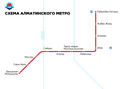 Схема метро Алматы (2022).png 757 × 564; 42 KB
-
 Третья линия Алматинского метрополитена.svg 744 × 800; 37 KB


.png)


.svg)


.png)


.png)
.jpg)
.png)

.png)

![[1]](http://www.almaty-metro.narod.ru/history/1980b.jpg)
![[2]](http://www.almaty-metro.narod.ru/history/1983b.jpg)
![[3]](http://www.almaty-metro.narod.ru/history/1985b.jpg)
![[4]](http://photofile.ru/photo/xpepper/3110101/65507214.jpg)
![[5]](http://trackmap.ru/img/tm_almaty.png)
![[6]](http://urbanrail.net/as/alma/almaty-map.png)
![[7]](http://alfacar.kz/static/img/photos/b2/43/b2439098a4723e33e48df6d3e1123ff9.jpeg)
![[8]](http://pics.kz/s6/4c/41/c7/4c41c7cb0f06b87a60c355ffce918752.jpg)
![[9]](https://upload.wikimedia.org/wikipedia/commons/thumb/c/cf/A%C5%82ma-ackie_metro.JPG/706px-A%C5%82ma-ackie_metro.JPG)
![[10]](https://upload.wikimedia.org/wikipedia/commons/thumb/1/14/Almaty_metro_map_de.svg/558px-Almaty_metro_map_de.svg.png)
![[11]](http://i041.radikal.ru/0710/a4/8a69ec1e4bfbt.jpg)
![[12]](http://photofile.ru/photo/xpepper/3110101/65507601.gif)
![[13]](http://pics.kz/s1/6a/67/18/36/6a671836d336d30b41689b330dba976b.jpg)
![[14]](http://www.almaty-metro.narod.ru/map/2011-1b.jpg)
![[15]](http://pics.kz/s3/b0/a7/af/34/b0a7af34f7a67fc99cdd4238886612a2.png)
![[16]](http://almaty-metro.narod.ru/map/sh2007_1b.jpg)
![[17]](http://www.almaty.kz/admin/upload/files/shema_razvitiya_metro.jpg)
![[19]](http://people.reed.edu/~reyn/Almaty.jpg)