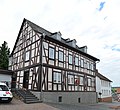
Category:Alte Amtsapotheke (Bad Camberg)
Jump to navigation
Jump to search
| Object location | | View all coordinates using: OpenStreetMap |
|---|
 | |||||
| Upload media | |||||
| Instance of | |||||
|---|---|---|---|---|---|
| Location | Bad Camberg, Limburg-Weilburg, Giessen Government Region, Hesse, Germany | ||||
| Street address |
| ||||
| Heritage designation | |||||
 | |||||
Media in category "Alte Amtsapotheke (Bad Camberg)"
The following 5 files are in this category, out of 5 total.
-
 Alte Amtsapotheke Bad Camberg.jpg 3,264 × 2,448; 2.59 MB
-
 Bad Camberg - Amtsapotheke.jpg 2,000 × 1,500; 433 KB
-
 Bad Camberg, Alte Amtsapotheke (1).JPG 3,064 × 2,662; 4.09 MB
-
 Bad Camberg, Alte Amtsapotheke.jpg 5,280 × 4,829; 11.3 MB
-
 Bad Camberg, Am Amthof 4.JPG 3,264 × 4,928; 8.91 MB

.JPG)

