Category:Alte Säge, Menziken
Jump to navigation
Jump to search
| Object location | | View all coordinates using: OpenStreetMap |
|---|
|
This is a category about a cultural property of regional significance in Switzerland with KGS number 15577
|
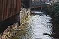
buildings in Menziken in the canton of Aargau, Switzerland  | |||||
| Upload media | |||||
| Instance of | |||||
|---|---|---|---|---|---|
| Part of | |||||
| Location | Menziken, Kulm District, Aargau, Switzerland | ||||
| Street address |
| ||||
| Heritage designation | |||||
| official website | |||||
 | |||||
Media in category "Alte Säge, Menziken"
The following 4 files are in this category, out of 4 total.
-
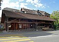 MenzikenSagi.jpg 4,891 × 3,500; 10.97 MB
-
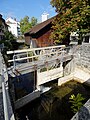 MenzikenSagiBarrage.jpg 3,888 × 5,184; 9.74 MB
-
 MenzikenSagiDetail.jpg 5,184 × 3,888; 9.56 MB
-
 Wyna en Menziken 173.jpg 3,872 × 2,592; 4.25 MB


