Category:Alte paritätische Kirche Romanshorn
Jump to navigation
Jump to search
| Object location | | View all coordinates using: OpenStreetMap |
|---|
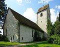
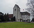
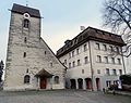
church building in Romanshorn in the canton of Thurgau, Switzerland _paritaetische-Kirche.JPG)  | |||||
| Upload media | |||||
| Instance of | |||||
|---|---|---|---|---|---|
| Part of | |||||
| Location |
| ||||
| Street address |
| ||||
| Heritage designation |
| ||||
| Inception |
| ||||
| Religion or worldview | |||||
 | |||||
|
This is a category about a cultural property of national significance in Switzerland with KGS number 5145
|
Subcategories
This category has only the following subcategory.
Media in category "Alte paritätische Kirche Romanshorn"
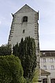
The following 24 files are in this category, out of 24 total.
-
 Alte Kirche - panoramio (2).jpg 2,816 × 2,120; 1.5 MB
-
 Alte Kirche und Schloss - panoramio.jpg 2,816 × 2,120; 1.45 MB
-
 ETH-BIB-Romanshorn mit Bodensee, Blick von Osten-LBS H1-017573.tif 6,439 × 4,486; 82.84 MB
-
 ETH-BIB-Romanshorn v. S. W. aus 300 m-Inlandflüge-LBS MH01-004109.tif 5,875 × 3,964; 66.79 MB
-
 ETH-BIB-Romanshorn, Schlosshotel am Bodensee, Blick von Osten-LBS H1-017570.tif 6,439 × 4,505; 83.14 MB
-
 ETH-BIB-Romanshorn, Schlosshotel am Bodensee, Blick von Osten-LBS H1-017571.tif 6,446 × 4,505; 83.19 MB
-
 ETH-BIB-Romanshorn, Schlosshotel am Bodensee, Blick von Osten-LBS H1-017572.tif 6,430 × 4,490; 82.79 MB
-
 ETH-BIB-Romanshorn-Inlandflüge-LBS MH01-006950.tif 6,513 × 4,747; 88.6 MB
-
 ETH-BIB-Romanshorn-LBS H1-019239.tif 6,503 × 4,535; 84.44 MB
-
 Hafenmauer - panoramio.jpg 2,681 × 1,788; 1.62 MB
-
 KGS-5145 Romanshorn (7) paritaetische-Kirche.JPG 3,838 × 3,000; 2.93 MB
-
 Romanshorn - panoramio (69).jpg 2,848 × 4,272; 8.99 MB
-
 Romanshorn - panoramio (73).jpg 4,272 × 2,848; 11.61 MB
-
 Romanshorn - panoramio (76).jpg 2,848 × 4,272; 9.52 MB
-
 Romanshorn - panoramio (85).jpg 2,848 × 4,272; 9.96 MB
-
 Romanshorn - panoramio (93).jpg 2,848 × 4,272; 7.97 MB
-
 Romanshorn-Alte-Kirche.jpg 2,000 × 1,333; 2.28 MB
-
 Romanshorn-Schloss.jpg 911 × 600; 167 KB
-
 RomanshornAlteKircheSchloss.jpg 4,570 × 3,768; 11.85 MB
-
 RomanshornParitaetischeKirche.jpg 2,539 × 3,800; 8.7 MB
-
 RomanshornParitaetischeKircheAussen.jpg 4,471 × 3,888; 11.25 MB
-
 RomanshornParitaetischeKircheTuer.jpg 3,490 × 4,640; 9.84 MB
-
 RomanshornSchlossberg.jpg 4,918 × 3,888; 11.79 MB
-
 RomanshornSchlossParitätischeKirche.jpg 2,553 × 2,744; 4.45 MB
.jpg)


.jpg)
.jpg)
.jpg)
.jpg)
.jpg)


