Category:Altes Schulhaus (Lichtenberg)
Jump to navigation
Jump to search
| Object location | | View all coordinates using: OpenStreetMap |
|---|
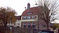
school building in Lichtenberg  | |||||
| Upload media | |||||
| Instance of | |||||
|---|---|---|---|---|---|
| Location | Lichtenberg, Fischbachtal, Darmstadt-Dieburg, Darmstadt Government Region, Hesse, Germany | ||||
| Street address |
| ||||
| Heritage designation | |||||
| Inception |
| ||||
 | |||||
This is the category of the Hessian Kulturdenkmal (cultural monument) with the ID Unknown? (Wikidata)
|
Media in category "Altes Schulhaus (Lichtenberg)"
The following 3 files are in this category, out of 3 total.
-
 Fischbachtal Lichtenberg Waldstraße 13 01.jpg 4,608 × 2,592; 6.72 MB
-
 Fischbachtal Lichtenberg Waldstraße 13 Schulhaus.jpg 4,608 × 2,592; 5.45 MB
-
 Fischbachtal Lichtenberg Waldstraße 13.jpg 4,608 × 2,592; 9.07 MB

